
Haliç – Karadeniz light railway
| Haliç – Karadeniz Haliç – Kemerburgaz dekovil hattı light railway |
|
|---|---|
 Twin locomotive No. 59
| |
 Former route on a modern map
| |
| Route length: | 62 km |
| Gauge : | 600 mm ( narrow gauge ) |
The Haliç – Karadeniz light railway ( Turkish: Haliç – Karadeniz sahra hattı , colloquially: Haliç-Kemerburgaz dekovil hattı ) was a 62-kilometer narrow-gauge railway from 1916 to 1956 from the Golden Horn (Haliç) to the Black Sea (Karadeniz) near Istanbul .
history


The light railroad was relocated in 1915 to supply the Silahtarağa power station with lignite from the open pit near Ağaçlı in the north of the city of Istanbul. The power station, which was initially supplied with coal from England and Zonguldak by sea , had difficulties with the coal supply during the First World War, as the ships of the Şirket-i Hayriye shipping company leaving Zonguldak were sunk in the Black Sea by the Russian Navy.
On February 1, 1915, construction began on the first section of the line from Silahtarağa to Ağaçlı. The narrow-gauge railway was built by the Ayastefanos Şimendifer Alayı regiment and the Çorlu Amele Taburu labor battalion . The first section was completed in a short time and put into operation in July 1915.
When the coal mines could not respond to the steadily increasing demand for electricity, it was decided to lay a branch line to the coal mines in the village of Çiftalan . Work on the second section began on June 30, 1916. The branch line was put into operation on December 20, 1916. As a result, the daily capacity could be increased to 24 shuttle trips with 8 cars each. An average of 960 tons of coal were transported on the route every day.
Route
The railway line began at the Silahtarağa power station and ran north on the west bank of the Kâğıthane Deresi . After 19.5 km near Kemerburgaz, the route split into two branches to Göktürk and Kemerburgaz . One of the branches followed the Kâğıthane Deresi around the Uzunkemer and met the Black Sea in the village of Ağaçlı . The length of the route from Silahtarağa to Ağaçlı was 43 kilometers.
The other branch ran through the Belgrade Forest to the village of Çiftalan on the Black Sea. It was 14 km long from the junction at Kemerburgaz to the village of Çiftalan. Both branches were connected by a 5 km long link along the Black Sea coast and thus formed a ring in the north of Kemerburgaz, the total length was 62 kilometers.


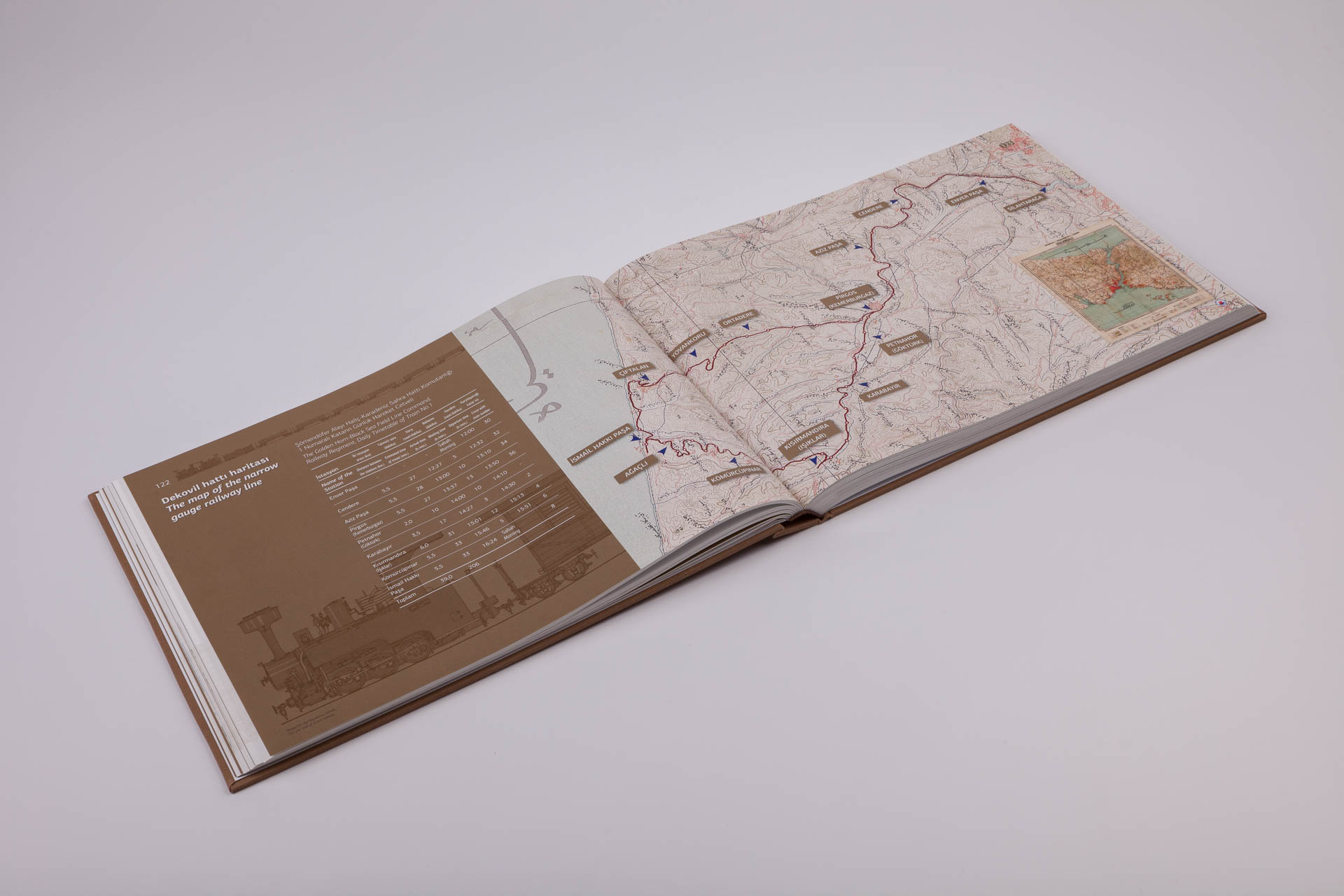
Each kilometer of the route was marked by a triangular stone with numbers on two sides. Every hundred meters there were smaller stones with numbers on one side. These stones can still be seen at certain points along the former route.
There were four main stations. The station closest to the city was Kâğıthane at 3.2 km. The main office of the management, which was responsible for the construction and operation of the line, was located here. Another station was the Kemerburgaz (Pirgos) station at 19.5 kilometers. The remaining two stations were in the villages of Ciftalan and Agacli, where the coal was extracted and loaded.
Since the line was single-track, there were a few passing points so that the trains could meet from opposite directions. Alternative points were in Cendere, Azizpaşa, Karabayır, Kısırmandıra and Kömürcüpınar on the route to Ağaçlı. On the branch line from Kemerburgaz to Çiftalan there were alternative points in Ortadere and Yovankoru. The geography of the region was not a big problem as the portion of the line between Silahtarağa and Kemerburgaz followed the plain on the banks of the Kağıthane stream. The route to Kemerburgaz and the separate branches towards Çiftalan and Ağaçlı, however, required terrain adjustments in many places. In addition, many bridges had to be built. Since all of these bridges were made of wood, none has survived.
Operation and closure


_Rayl%C4%B1_Sistem_Hatt%C4%B1.jpg)
The coal mines in the north of Istanbul lost their importance in the post-war period of World War I when normal order was restored. In 1922 the line was handed over to the Ministry of Commerce. After the proclamation of the republic, it was transferred to the Minister of Economics. Although he oversaw the operation of the line, the stations in the villages of Ağaçlı and Çiftalan were closed and the trains no longer stopped there. The section between the Kagithane and Kemerburgaz stations was assigned to the military. It was used continuously by the armed forces until 1956.
Operations were completely abandoned after the last remaining locomotives and wagons were scrapped. The tracks disappeared into the ground over time. The exposed sections were mined by scrap dealers. The route of the route is still easy to see in the suburban areas. Many milestones have been preserved in their places of origin in good condition.
Only one of the locomotives made in Germany has survived. It is kept and exhibited in the Eski Çeltek coal mine , which is part of the Amasya Province Special Administration . According to the latest newspaper reports, the German manufacturer wanted to buy the locomotive and display it in its own museum. In return, it proposed delivering construction machinery to the provincial special administration.
Reconstruction project
In 2008, the municipality of Kagithane initiated work to completely rebuild the narrow-gauge railway lines between the Golden Horn and the Black Sea for local public transport and tourist use. In the preliminary studies it was found that it is possible to rebuild the route true to the original. The route leads past remarkable aqueducts, bridges, villages, forests and farms.
Since the route of the former route is still not overgrown, no trees had to be felled when the line was rebuilt. The project took off when the Istanbul City Council also became interested in the subject. A monument protection application for the route has been submitted to the monument authority.
See also
further reading
- Mert Sandalcı, Emre Dölen, Hüseyin Irmak, Alan Prior and Şevki Sevgin: 100 years later on the Trail of a lost railway… ISBN 978-975-7710-45-5 . (Preview to scroll through using arrow symbols <and>)
Web links
Individual evidence
- ↑ Hüseyin Irmak: Silahtarağa'dan Karadeniz'e Bir Dekovil Hattı.
- ↑ Mert Sandalcı, Emre Dölen, Hüseyin Irmak, Alan Prior and Şevki Sevgin: 100 years later on the Trail of a lost railway… pp. 122–123.
- ↑ Son Güncelleme: Haliç-Kemerburgaz Dekovil hattı hayata geçiyor (TT Arena İstasyonu'nda entegre olacak). NTV, November 29, 2016
- ↑ a b c d Haliç - Karadeniz Sahra Hattı Canlanıyor. December 1, 2008.
- ↑ a b c d Kayıp Demir yolu Dekovil Hatıı. December 7, 2010.
- ↑ a b c d Parlayan yıldız Kağıthane.
- ↑ Haliç'ten Karadeniz'e tren gidecek. Radikal, December 1, 2008.
Coordinates: 41 ° 4 ′ 2 ″ N , 28 ° 56 ′ 45 ″ E