
Gaping gill
Coordinates: 54 ° 11 ′ 40.7 " N , 2 ° 22 ′ 57.2" W.

Gaping Gill (also Gaping Ghyll ) is a natural cave shaft on the southeast flank of Mount Ingleborough in North Yorkshire and one of the largest cave spaces in Great Britain .
Fell Beck , a small watercourse, rises above the cave on the east flank of Ingleborough ( 54 ° 9 ′ 23 ″ N , 2 ° 22 ′ 49 ″ W ) and flows into the cave, being the highest underground with a drop of 105 meters Waterfall forms. At the bottom of the cave, the water sinks into the ground and flows underground to the Ingleborough Cave , which it leaves as Clapham Beck and continues over the River Wenning into the River Lune .
The Bradford Pothole Club and the Craven Pothole Club provide access to Gaping Gill with the help of a winch twice a year.
photos
- Gaping gill
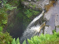
Fell Beck, top of the waterfall

At the bottom of the cave on a day of sightseeing


literature
- Howard M. Beck: Gaping Gill. 150 years of exploration. Robert Hale, London 1984, ISBN 0-7090-1552-6 .
- Alan Brook, David Brook, Julian Griffiths, Malcolm H. Long: The Three Peaks (= Northern Caves. Vol. 2). Dalesman Press, Clapham via Lancaster 1991, ISBN 1-85568-033-5 .
- Edmund J. Mason: Caves and Caving in Britain. Robert Hale, London 1977, ISBN 0-7091-6195-6 .