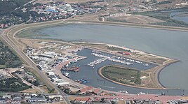
Fishing port (Norderney)
|
Fishing port
City of Norderney
|
|
|---|---|
| Coordinates: 53 ° 42 ′ 32 " N , 7 ° 10 ′ 11" E | |
| Height : | 5 (3–5) m above sea level NHN |
| Postal code : | 26548 |
| Area code : | 04932 |
|
Overview map of the island of Norderney
|
|
|
The district with the port and the commercial area adjacent to the north
|
|
The district of Fischerhafen is located in the southeast of the Lower Saxon town of Norderney on the East Frisian island of the same name in the Aurich district .
geography
In addition to the port of Norderney , from which the shipping company Norden-Frisia has a scheduled ferry connection to Norddeich , the island's industrial area belongs to the fishing port .
literature
- Jann Saathoff: Norderney . tape 1 - The structural development of the island of North Sea Island. Soltau-Kurier-Norden, Norden 2010, ISBN 978-3-939870-82-1 .


