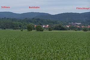
Flötschkopf
| Flötschkopf | ||
|---|---|---|
|
View from the east |
||
| height | 421.2 m above sea level HN | |
| location | Thuringia ( Germany ) | |
| Mountains | Richelsdorf Mountains | |
| Coordinates | 51 ° 0 '6 " N , 10 ° 3' 48" E | |
|
|
||
| rock | Red sandstone | |
The Flötschkopf is a 421.2 m high, fully wooded elevation and is located in the Gerstunger Forest, a closed forest area of the municipality of Gerstungen in the Wartburg district in Thuringia .
The field name "Hopfenrain" on the eastern slope of the Flötschkopf reveals a cleared area and hop cultivation. This is also where the Flötschgraben stream rises. Presumably , wood was felled for the Weser rafts on the Flötschkopf and its northern neighbor, the Schiffskopf . The Creuzburger Saline Wilhelmsglücksbrunn also obtained verifiably wood from the Gerstung forests. The forests on the Flötschgraben were the cheapest to reach. During the GDR era, the Gerstung Forest was inaccessible in the restricted area.
Individual evidence
- ↑ Official topographic maps of Thuringia 1: 10,000. Wartburgkreis, district of Gotha, district-free city of Eisenach . In: Thuringian Land Survey Office (Hrsg.): CD-ROM series Top10 . CD 2. Erfurt 1999.
- ^ Horst Schmidt: History of the Creuzburger Salzwerk . In: Eisenach Information (Hrsg.): Eisenacher Schriften zur Heimatkunde . Issue 39. Eisenach 1988, p. 32-48 .

