Ibaraki airport
| Ibaraki airport |
|
|---|---|

|
|
| Characteristics | |
| ICAO code | RJAH |
| IATA code | IBR |
| Coordinates | |
| Height above MSL | 32.6 m (107 ft ) |
| Transport links | |
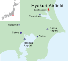
| Distance from the city center | 80 km northeast of Tokyo |
| Street | Prefecture Street 359 |
| train | JR East |
| Basic data | |
| opening | 1937 |
| operator | JASDF |
| Runways | |
| 03R / 21L | 2700 m × 300 m asphalt |
| 03L / 21R | 2700 m × 150 m asphalt |
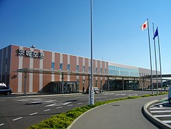
The Ibaraki Airport ( Jap. 茨城空港 , Ibaraki-Kuko ) is a civilian-military airport near the town Omitama , Ibaraki Prefecture , Japan .
history
Originally, the airport was used as the Hyakuri airfield ( 百里 飛行 場 , Hyakuri-hikōjō ) by the air self - defense forces .
Due to the high occupancy of the two Tokyo airports Narita and Haneda , this was renamed Ibaraki Airport on March 11, 2010 and civil air traffic began. In addition, it will continue to be used by the armed forces around the clock . A second runway was built to cope with the additional air traffic .
Airlines and Destinations
The Japanese low-cost airline Skymark flies from Ibaraki to the airports of Kobe , Naha , New Chitose and Fukuoka . The Chinese airline Spring Airlines provides an international connection to Shanghai .
Transport links
The two nearby JR rail stations Ishioka and Shin-Hokota be supplied with a regular bus service since the opening of civil Ibaraki airport. The airport is the end point of the short prefecture road 359 which is connected via prefecture road 360 to prefecture road 50 to the prefecture capital Mito .
Individual evidence
- ↑ Airport information with map for illustration
- ↑ Airline Information , accessed on August 11, 2017
Web links
- Airport website (Japanese, English, Korean, Chinese)

