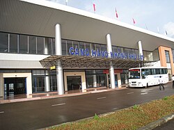
Phu Cat Airport
| Sân bay Phù Cát | |
|---|---|

|
|
| Characteristics | |
| ICAO code | VVPC |
| IATA code | UIH |
| Coordinates | |
| Height above MSL | 24 m (79 ft ) |
| Transport links | |
| Distance from the city center | 30 km northwest of Qui Nhơn |
| Basic data | |
| opening | 1966 |
| Start-and runway | |
| 15/33 | 3051 m × 45 m concrete |
The Phu Cat Airport (IATA: UIH, ICAO: VVPC) on Vietnamese Sân bay Phu Cát is an airport near the city of Quy Nhon in Vietnam , Asia.
The airport was established by the United States during the Vietnam War in 1966 and was used by the Vietnamese armed forces after 1975 and converted into a regional commercial airport.
Web links
- Airport data on World Aero Data ( 2006 )