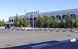
Turkmenabat Airport
| Türkmenabat şähiniň howa menzil | |
|---|---|

|
|
| Characteristics | |
| ICAO code | UTAV |
| IATA code | CRZ |
| Coordinates | |
| Height above MSL | 192 m (630 ft ) |
| Transport links | |
| Distance from the city center | 3 km east of Türkmenabat , Turkmenistan |
| Basic data | |
| Capacity ( PAX per year) |
300 passengers / hour |
| Start-and runway | |
| 15/33 | 2750 m × 42 m asphalt |
The Turkmenabat Airport ( IATA code : CRZ , ICAO code : UTAV ), alternatively Chardzhou airport , or in English Turkmenabat Airport , one is Turkmen commercial airport in the city of Turkmenabat , as Chardzhou known. The airport's IATA code is derived from the latter city name. The airport is located immediately east of the city center on the outskirts of Türkmenabat.
The airport was modernized in 2010 and can handle 300 passengers per hour.
As of May 2012, the airport is only served by the local state airline Turkmenistan Airlines , which commutes from here several times a day to the state capital Ashgabat and from here also flies to Daşoguz twice a week. Boeing 717 jets are used on both routes .
Individual evidence
- ↑ turkmenairlines.com: Airport Turkmenabat ( Memento of the original from November 13, 2012 in the Internet Archive ) Info: The archive link has been inserted automatically and has not yet been checked. Please check the original and archive link according to the instructions and then remove this notice.
- ↑ turkmenairlines.com: Timetable and route map ( Memento of the original from May 3, 2013 in the Internet Archive ) Info: The archive link was inserted automatically and has not yet been checked. Please check the original and archive link according to the instructions and then remove this notice.
Web links
- Airport data from World Aero Data (English)