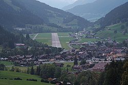
Saanen airfield
| Saanen airfield | |
|---|---|

|
|
| Characteristics | |
| ICAO code | LSGK |
| Coordinates | |
| Height above MSL | 1008 m (3307 ft ) |
| Transport links | |
| Distance from the city center | 2.8 km northwest of Gstaad |
| Basic data | |
| operator | Gstaad-Saanenland Airport Cooperative |
| Start-and runway | |
| 08/26 | 1400 m × 40 m asphalt |
The Saanen Airport ( ICAO code LSGK ) is an airfield in Saanen in the Swiss canton of Bern .
The airfield was built as a Reduit airfield during World War II and was used as a military airfield until the 1980s . The airfield has been owned by a civil cooperative since 2011.
An underground, formerly military facility at the airfield is one of the two locations of the highly secure Swiss Fort Knox data center .
Web links
Commons : Saanen Airport - Collection of images, videos and audio files