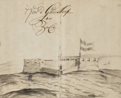
Fort Goede Hoop
Fort Goede Hoop was an originally Dutch fortress on the coast of Ghana near Senya Beraku , which was restored in the 1960s.
The Dutch had already established a small trading post here in the 1660s , but abandoned it when the British built a fortress in neighboring Winnebah . In 1702 they then built the almost triangular fortress, which one year later was named Goede Hoop , meaning “Good Hope”. The hope of the Dutch to benefit from the region's gold trade through Goede Hoop was hardly ever fulfilled. Later the slave trade proved to be profitable here. When the complex became too small in 1715, the Dutch doubled it by removing the diagonal wall and building a more or less rectangular shape from the triangular one. In the second half of the 18th century, the fortress was reinforced by an outer wall, of which no traces can be seen today. In 1867 the fortress came into British possession as part of the fortress exchange between the Netherlands and Great Britain .
Goede Hoop was the last fortress that European powers built on the coast of Ghana and is now used as a guest house .
Individual evidence
- ↑ Nationaal Archief, The Hague, Verzameling Buitenlandse Kaarten Leupe, number toegang 4.VEL, inventory number 791: http://www.gahetna.nl/collectie/archief/inventaris/index/eadid/4.VEL/inventarisnr/791/level / file
- ^ Albert van Dantzig: Forts and Castles of Ghana. Accra 1980, p. 49
- ↑ http://www.ghanamuseums.org/forts/fort-good-hope.php
Web links
Coordinates: 5 ° 23 ′ 15 " N , 0 ° 29 ′ 23.2" W.


