
Fort San Sebastian (Ghana)


The Fort San Sebastian ( Portuguese Forte de São Sebastião ) in the place Shama in today's Ghana was built from 1523 as one of the first European trade fortresses on the so-called Gold Coast (see Historical forts of Ghana ). Since 1979 the fort has been a UNESCO World Heritage Site as part of the fortress landscape there .
history
The fort originally served to secure the Portuguese Gold Coast . A first temporary fortress was built on this site by the Portuguese between 1520 and 1526. From 1546 the first permanent fortified stone palisade with a tower was built. The forerunner of today's fort was built in the 1620s. The construction took up elements of the Mazagão fortress built by the Portuguese from 1541 in Morocco . It has been referred to as a small copy of the Castelo de São Jorge in Lisbon and is recorded on a Venetian map from 1564.
In 1638 troops of the Dutch West India Company occupied the meanwhile abandoned Portuguese fort. The Dutch took possession of the fort, which had largely become a ruin, and between 1640 and 1643 had it restored and considerably expanded. From January 9, 1642 the fort belonged to the Dutch possessions on the Gold Coast by cession of Portugal .
During the 17th century Atlantic slave trade , people were held captive in the fort before being shipped to North America. In addition to the slave trade, the records of the Dutch West India Company also report gold trade; In 1705, however, besides the functions as a base for firewood and water supply, no more trading activity was recorded. In 1664 the British besieged the fort in vain (according to other sources they captured it briefly, but lost it again to the Dutch in the same year). In the 1750s Germany's first black professor, Anton Wilhelm Amo , lived in the fortress; it is unclear whether he was held there by Dutch people. Between 1765 and 1783 there was a cotton plantation near the fort.
In 1872 the fortress, which had already been abandoned by the Dutch , became British through the Sumatra Treaty , which regulated the exchange of some colonial possessions between Great Britain and the Netherlands. In 1972 the fort was declared a national monument and has been a UNESCO World Heritage Site since 1979, Forts and Castles, Volta, Greater Accra, Central and Western Regions . Today the fort is the seat of various authorities and a post office and is open to visitors.
state of construction
Little remains of the original Portuguese fort. It was given its present form mainly by the Dutch from 1664 onwards. The hill on which the fortress rises consists of soft laterite rock that can easily be washed away by the heavy rainfall here. As a result, the masonry was often damaged. Attempts were made to counteract this with support structures on the outer masonry. The striking wide staircase that characterizes the entire building today and that leads up to the entrance gate of the fortress is intended to conceal this damage. Between 1954 and 1957 the fortress was restored and is now the seat of various authorities.

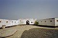
Fort and town from the sea
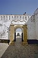
In the background the main entrance with steps to Shama

View of Shama from the fort
front


literature
- Albert Van Dantzig: Forts and Castles of Ghana. Sedco Publishing, Accra 1980, ISBN 9964-72-010-6 .
- Kwesi J. Anquandah: Castles and Forts of Ghana. Atalante, Paris 1999, ISBN 2-9513901-0-6 , p. 67.
Web links
- Fort San Sebastian, Shama (1526). In: Ghana Museums (English)
- Fort St Sebastian, Shama (Western region of Ghana). In: Ghana-net.com (English)
- Entry in the UNESCO World Heritage List (English)
Remarks
- ↑ a b c d e f Fort of São Sebastião de Shama. In: Fortalezas.org (Portuguese).
- ↑ Fort San Sebastian, Shama (1526). In: Ghana Museums (English).
- ↑ a b c d Fort St Sebastian, Shama (Western region of Ghana). In: Ghana-net.com (English).
- ↑ Hannelore Heckmann: Anton Wilhelm Amo (approx. 1707 – approx. 1756). On the Reception of a Black Philosopher. In: Lessing Yearbook. Volume 23, 1990, pp. 149-158, here p. 152 ; William E. Abraham: The Life and Times of Anton Wilhelm Amo, the First African (Black) Philosopher in Europe. In: Molefi K. Asante, Abu Shardow Abarry (eds.): African Intellectual Heritage: A Book of Sources. Temple University Press, Philadelphia 1996, pp. 424-439, here p. 438.

Coordinates: 5 ° 0 ′ 39 " N , 1 ° 37 ′ 45.1" W.