Franklin Glacier
| Franklin Glacier | ||
|---|---|---|
|
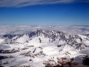
South flank of Mount Waddington with source and tributary glaciers of the Franklin Glacier |
||
| location | British Columbia ( Canada ) | |
| Mountains | Pacific Ranges ( Coast Mountains ) | |
| Type | Valley glacier | |
| length | 18.5 km | |
| Exposure | southwest | |
| Altitude range | 2000 m - 700 m | |
| width | ⌀ 1.5 km | |
| Coordinates | 51 ° 17 ′ N , 125 ° 23 ′ W | |
|
|
||
| drainage | Franklin River → Knight Inlet | |
|
The Franklin Glacier's nutrient zone; the Franklin Glacier in the lower right of the picture |
||
The Franklin Glacier is located in the southern Coast Mountains in the Canadian province of British Columbia .
The 18.5 km long and on average 1.5 km wide valley glacier drains a glaciated region on the southern flank of Mount Waddington . It arises at the junction of several source glaciers (Finality, Fury, Regal and Dais glaciers) at an altitude of 2000 m 7.3 km west-southwest of Mount Waddington. The Franklin Glacier initially flows 7 km south-southeast. From the west, the Shelf and Whitetip glaciers and from the east, the Corridor and Agur glaciers meet the Franklin glacier. This now turns towards the west-south-west and later to the south-west. The glacier tongue is at an altitude of about 700 m . The meltwater reaches Knight Inlet, 20 km further south , via the Franklin River . The glacier is on the retreat.
To the southwest of the nutrient area of the Franklin Glacier is the center of an extinct volcano, the so-called Franklin Glacier Volcano .
Web links
- Franklin Glacier . In: BC Geographical Names (English)


