Knight Inlet
| Knight Inlet | ||
|---|---|---|
|
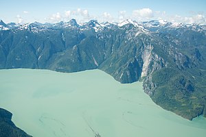
View of the west bank |
||
| Waters | Pacific Ocean | |
| Land mass | North America | |
| Geographical location | 50 ° 41 ′ N , 126 ° 1 ′ W | |
|
|
||
| width | 2.8 km | |
| length | 127 km | |
| surface | 400 km² | |
| Tributaries | Klinaklini River , Franklin River | |
|
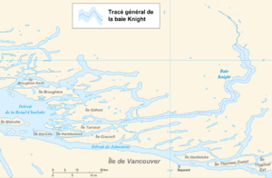
Location of Knight Inlet (French lettering) |
||
The Knight Inlet is a fjord on the west coast of the Canadian province of British Columbia .
The 127 km long fjord is located in the Regional District of Mount Waddington . The bay, which is around 2.8 km wide on average, initially runs 72 km to the east and then meanders 55 km north into the Pacific Ranges in the south of the Coast Mountains . The glacier-fed rivers Klinaklini River and Franklin River flow into the northern head end . The western outer bay section is flanked in the north by the islands of Gilford Island , Viscount Island and Midsummer Island . The Tribune Channel branches off from Knight Inlet to the north and separates Gilford Island from the mainland. On the opposite southern side of the bay are the islands of Turnour Island , Minstrel Island , Village Island , Crease Island and Swanson Island . The Chatham Channel and the Clio Channel branch off to the south. The Knight Inlet opens onto Queen Charlotte Street . Opposite the bay output is the Vancouver Iceland offshore island Malcolm Iceland . The bay forms roughly the southern end of the Great Bear Rainforest .
The bay was first mapped in 1792 by William Robert Broughton , a member of George Vancouver's expedition .
Web links
- Knight Inlet . In: BC Geographical Names (English)


