Regional District of Mount Waddington
| Mount Waddington | |
|---|---|
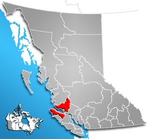
 Location of the region in British Columbia
|
|
| Basic data | |
| Country | Canada |
| province |
British Columbia
|
| Administrative headquarters | Port McNeill |
| Coordinates : | 50 ° 45 ′ N , 127 ° 0 ′ W |
| Residents | 11,035 (as of 2016) |
| surface | 20,244.27 km² |
| Population density | 0.5 inhabitants / km² |
| Time zone : | Pacific Standard Time ( UTC −8) Pacific Daylight Time ( UTC −7, daylight saving time) |
| Web presence | www.rdmw.bc.ca |
The Regional District of Mount Waddington is a district in the Canadian province of British Columbia . It covers both an area on the northern tip of Vancouver Island and an area on the west coast of the mainland, is 20,244.27 km² and has a population of 11,035 (2016). In the 2011 census, 11,506 residents were identified. The main town is Port McNeill .
Administrative structure
cities and communes
| place | status | population |
| Alert Bay | Village | 489 |
| Port Alice | Village | 664 |
| Port Hardy | District municipality | 4.132 |
| Port McNeill | Town | 2,337 |
Unregulated areas
- Mount Waddington A
- Mount Waddington B
- Mount Waddington C
- Mount Waddington D
Web links
Individual evidence
- ^ Census Profile, 2016 Census. November 16, 2017, accessed March 13, 2018 .
- ^ Census Profile, 2016 Census - Provincial Data. August 9, 2019, accessed September 26, 2019 .