Metro Vancouver
| Greater Vancouver | |
|---|---|
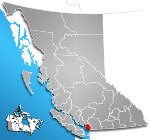
 Location of the region in British Columbia
|
|
| Basic data | |
| Country | Canada |
| province |
British Columbia
|
| Administrative headquarters | Burnaby |
| Coordinates : | 49 ° 15 ′ N , 123 ° 0 ′ W |
| Residents | 2,463,358 (as of 2016) |
| surface | 2,882.68 km² |
| Population density | 854.5 inhabitants / km² |
| Time zone : | Pacific Standard Time ( UTC −8) Pacific Daylight Time ( UTC −7, daylight saving time) |
| Web presence | www.metrovancouver.org |
The Metro Vancouver (legally Greater Vancouver Regional District ) is a regional district in the Canadian province of British Columbia . It encompasses the metropolitan area around the city of Vancouver and consists of 21 parishes. Although these are independent, they transfer certain public administration services to the regional district. The administrative seat of the regional district is Burnaby , while Vancouver is the largest city.
Colloquially, the Metro Vancouver area is often referred to as Greater Vancouver , although Greater Vancouver only refers to the urban areas within the regional district. As defined by Statistics Canada , the Census Metropolitan Area has the same area as the regional district.
geography
The district is located in the southwest of the province and borders directly on the USA . In the 2016 census, the population was 2,463,431, the metro covers an area of 2,882.68 km². Of the 30 largest parishes in the province, 13 are in Greater Vancouver.
cities and communes
The district consists of 21 municipalities and a municipality-free area (as of 2016):
| local community | type | Residents |
|---|---|---|
| Anmore | Village (Village) |
2.210 |
| Belcarra | Village (Village) |
643 |
| Bowen Island | Island community (Iceland municipality) |
3,680 |
| Burnaby | City (City) |
232.755 |
| Coquitlam | City (City) |
139.284 |
| delta | District Municipality (District municipality) |
102,238 |
| Langley | City (City) |
25,888 |
| Langley | District Municipality (District municipality) |
117.285 |
| Lions Bay | Village (Village) |
1,334 |
| Maple Ridge | District Municipality (District municipality) |
82,256 |
| New Westminster | City (City) |
70.996 |
| North Vancouver | City (City) |
52,898 |
| North Vancouver | District Municipality (District municipality) |
85.935 |
| Pitt Meadows | City (City) |
18,573 |
| Port Coquitlam | City (City) |
58,612 |
| Port Moody | City (City) |
33,551 |
| Richmond | City (City) |
198,309 |
| Surrey | City (City) |
517.887 |
| Vancouver | City (City) |
631.486 |
| West Vancouver | District Municipality (District municipality) |
42,473 |
| White rock | City (City) |
19,952 |
The Greater Vancouver Electoral Area A includes all unincorporated areas in Metro Vancouver. In 2016, the population of these areas was 16,133. There are also 17 Indian reservations of the First Nations , which self-government was granted and are not under a municipality or the district. In 2011 a total of 6,525 people lived there.
Administrative role
The basic responsibilities of Metro Vancouver are the management of the natural resources and services needed throughout the district. This includes urban planning, water supply and sewerage, wastewater treatment, transportation, traffic and parks, among others.
Metro Vancouver oversees TransLink , which is responsible for public transportation, bridges and highways across the region. TransLink also operates the AirCare program, which aims to reduce pollutant emissions from automobiles.
Web links
Individual evidence
- ↑ a b Census Profile, 2016 Census. Statistics Canada, November 16, 2017, accessed March 8, 2018 .
- ^ Geographic hierarchies, Census Profile, 2016 Census. Statistics Canada, November 16, 2017, accessed March 8, 2018 .
