North Vancouver (District)
| District of North Vancouver | ||
|---|---|---|
 North Vancouver from the water |
||
| Location in British Columbia | ||
|
|
||
| State : |
|
|
| Province : | British Columbia | |
| Regional District : | Metro Vancouver | |
| Coordinates : | 49 ° 19 ′ N , 123 ° 1 ′ W | |
| Area : | 160.76 km² | |
| Residents : | 84,412 (as of 2011) | |
| Population density : | 525.1 inhabitants / km² | |
| Time zone : | Pacific Time ( UTC − 8 ) | |
| Mayor : | Richard Walton | |
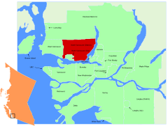
 Location in the Vancouver area |
||
North Vancouver is a district municipality in the southwest of the Canadian province of British Columbia . It is located northeast of Vancouver on the north bank of Burrard Inlet , belongs to the district of Metro Vancouver and, together with the communities of North Vancouver and West Vancouver, forms the North Shore region (literally: north bank ).
geography
The community encloses the city of the same name on three sides; it is bounded by the Capilano River in the west (named after Joseph Capilano ), the Indian Arm in the east, the Burrard Inlet in the south and the North Shore Mountains in the north. It extends in an east-west direction over the steep southern slopes of Grouse Mountain , Mount Seymour and other mountains. Numerous streams flow into the Burrard Inlet from the mountain slopes, including the MacKay River, Mosquito River, Lynn River, and Seymour River.
There is no actual urban center, but there are several service centers. From east to west these are Edgemont Village, Upper Lonsdale, Lynn Valley, Main Street, Parkgate, and Deep Cove. Most of the residents live in single-family houses. Apart from the older town centers, the area has only been settled since the 1950s. There are commercial zones on the banks of the fjord.
The District of North Vancouver and the City of North Vancouver are two independent local authorities with their own mayors, city councils and municipal utilities . However, they form a common school district and share a police station of the Royal Canadian Mounted Police . The district municipality has around twice as many inhabitants as the city, but the population density is significantly lower.
history
Settlement by Europeans began in 1862 when lumberjacks began to cut trees in the pristine forests, which were then loaded onto ships. The area had previously been traditional hunting and settlement areas for the First Nations , especially the Squamish people . Sewell Moody built a water-powered sawmill in 1865. Several settlements developed on the north bank of Burrard Inlet, the first being Moodyville. In 1891 the North Vancouver community was founded. After a severe financial crisis, the community was divided into three parts in 1907; the city of the same name, North Vancouver and West Vancouver, emerged .
At the beginning of the 20th century, the area was marked by a real estate boom, and the British poet Rudyard Kipling was one of the speculators . In 1906, the British Columbia Electric Railway's tram began operating. Shipyards were built on the shore, all of which have since died down. The Pacific Great Eastern Railway and the Second Narrows Bridge , which opened in 1925, established a permanent connection to Vancouver.
During the Great Depression , the district municipality had to file for bankruptcy. But the construction of the Lions Gate Bridge in 1938 and warship production in the shipyards during World War II led to a renewed economic boom. After the war, the North Shore region became a popular, scenic residential area, but the district parish grew significantly faster than the city due to the larger land reserves.
Demographics
The census in 2011 showed a population of 84,412 inhabitants for the district municipality. The population only increased by 2.2% compared to the 2006 census, while the population in British Columbia grew by 7.0% at the same time.
Economy and Transport
While industry drove the development of North Vancouver for much of the 20th century, it was gradually replaced by light industrial companies that manufacture high-tech products. The area is also known as Hollywood North because numerous television series and films have been shot here. For example, five seasons of the X-Files series were made here .
The community is accessed through Highway 1 , a motorway-like part of the Trans-Canada Highway . It crosses the Burrard Inlet from Vancouver via the Ironworkers Memorial Second Narrows Crossing and continues to West Vancouver . On behalf of the transport company TransLink , the Coast Mountain Bus Company operates several bus routes that start at the SeaBus ferry terminal Lonsdale Quay in the city of Vancouver. Another multi-line bus company is West Vancouver Blue Bus .
Attractions
- The Capilano Suspension Bridge is a rope bridge and takes hikers across the Capilano River to numerous hiking trails and a rainforest path that runs high above the ground in the treetops.
- The Lynn Canyon Suspension Bridge is another rope bridge that crosses the deep gorge of the Lynn River.
- Grouse Mountain and Mount Seymour Provincial Park are popular winter sports and hiking areas, and Indian Arm Provincial Park is popular hiking and water sports areas.
- The Capilano River Regional Park extends around the Cleveland Dam with further hiking trails and a fish farm.
Web links
- North Vancouver ( English, French ) In: The Canadian Encyclopedia .
- Official website
Individual evidence
- ↑ Statistics Canada (2011 Census). North Vancouver District Municipality Profile , accessed July 17, 2012


