North Vancouver
| North Vancouver | ||
|---|---|---|
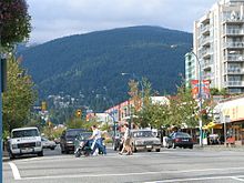
 North Vancouver and North Shore Mountains of Coal Harbor seen from |
||
| Location in British Columbia | ||
|
|
||
| State : |
|
|
| Province : | British Columbia | |
| Regional District : | Metro Vancouver | |
| Coordinates : | 49 ° 19 ′ N , 123 ° 5 ′ W | |
| Area : | 11.83 km² | |
|
Inhabitants : - Metropolitan Area : |
48,196 (as of 2011) 84,412 (as of 2011) |
|
| Population density : | 4,074 inhabitants / km² | |
| Time zone : | Pacific Time ( UTC − 8 ) | |
| Postal code : | V7G - V7R | |
| Mayor : | Darrell Mussatto | |
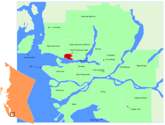
 Location in the Metro Vancouver area |
||
North Vancouver is a city in the southwest of the Canadian province of British Columbia . It is located on the north bank of Burrard Inlet directly across from Downtown Vancouver , belongs to the Metro Vancouver district and is one of three parishes in the North Shore region (literally: north bank ).
geography
The city is on three sides of the same district municipality and the southwestern part of a reserve of Squamish surrounded and located at the foot of Grouse Mountain and Mount Seymour , two popular excursion mountains in the North Shore Mountains .
The City of North Vancouver and the District of North Vancouver are two independent local authorities with their own mayors, city councils and municipal utilities . However, they form a common school district and share a police station of the Royal Canadian Mounted Police . The city is far more densely populated than the district municipality, has an urban character and is the center of the North Shore region. The population density is therefore relatively high, with numerous high-rise apartment buildings in the districts of Central Lonsdale and Lower Lonsdale in particular.
history
North Vancouver is the oldest settlement on the fjord Burrard Inlet and older than Vancouver itself. The only even older settlement in the region is New Westminster on the Fraser River . In the early 1860s, loggers began cutting Douglas firs and other trees in the pristine forests , which were then loaded onto ships. Sewell Moody built a water-powered sawmill in 1865. A village with a post office and schools was built around it and in 1891 the North Vancouver community was founded, which stretched over the entire north bank of the Burrard Inlet. The name was then still Moodyville, in honor of Sewell Prescott Moody. Financial crises led to the bankruptcy of the young community. As a result, West Vancouver and the district municipality of North Vancouver emerged, while the newly founded city of North Vancouver in 1907 only comprised a small part of the area.
Part of the responsibility for the bankruptcy were the high costs of developing the mountainous terrain. In addition, the shore area initially consisted mainly of swamps. The large distances and deeply incised Bachtobel also hindered development. The bridges were swept away by floods in winter.
The city, which was no longer responsible for the rural environment, developed well and became a popular suburb of Vancouver. Ferries brought commuters to work while trams and speculators opened up new residential areas. The Wallace Shipyard and the Pacific Great Eastern Railway brought industrial jobs with them, and from 1925 the Second Narrows Bridge established a permanent link to the south bank of Burrard Inlet. The Lions Gate Bridge followed in 1938, with the construction costs being entirely taken over by the Guinness brewery family in order to develop their 16 km² property in West Vancouver.
During the interwar period, sawmills, forestry operations and small farms still shaped the area. On the Grouse Mountain and on the Mount Seymour emerged ski resorts. During the Great Depression , the city went bankrupt again. But during the Second World War the economy was able to recover as the shipyards built numerous warships on the bank. After the end of the war, North Vancouver became an attractive place to live due to its proximity to Downtown Vancouver.
Demographics
The 2011 census showed a population of 48,196 inhabitants for the municipality. The population has increased by 6.7% compared to the 2006 census and is roughly on par with British Columbia, where the population increased by 7.0% over the same period. The surrounding North Vancouver district parish has an additional 84,412 residents.
Economy and Transport
There are several important companies in the city that are active in the fields of shipbuilding , chemical production and film production . Tourism is also important .
Two bridges - Lions Gate Bridge and Second Narrows Crossing - as well as the SeaBus connect North Vancouver with Vancouver. Highway 1 , a freeway-like section of the Trans-Canada Highway, runs through the northern part of the city .
On behalf of the transport company TransLink , the Coast Mountain Bus Company operates several bus routes that start at the SeaBus ferry terminal Lonsdale Quay .
Personalities
- Dan George (1899–1981), Indian chief and actor
- Stephen Arthur Jensen (* 1954), Roman Catholic Bishop
- Lisa Smedman (* 1959), fantasy and science fiction writer
- Bruce Harwood (born 1963), actor
- Craig Pedersen (born 1965), basketball player and coach
- Samantha Ferris (* 1968), actress
- Charles Montgomery (* 1968), writer and photojournalist
- Jason Priestley (born 1969), actor
- Dave Tomlinson (born 1969), ice hockey player
- Brent Olynyk (* 1971), badminton player
- Françoise Yip (* 1972), actress
- Trevor Guthrie (* 1973), singer
- Jarred Blancard (born 1973), actor
- Todd Simpson (born 1973), ice hockey player
- Leah Cairns (born 1974), actress
- Morgan Finlay (born 1974), singer-songwriter
- Tyron Leitso (* 1976), actor
- Steve Kariya (born 1977), ice hockey player
- Maëlle Ricker (* 1978), snowboarder
- Laurell Barker (* 1979), songwriter
- Nicole McKay (* 1979), actress
- Anna Rice (* 1980), badminton player
- Myles Ferguson (1981-2000), television and film actor
- Doug Lynch (born 1983), ice hockey player
- Cam Paddock (born 1983), ice hockey player
- Manuel Osborne-Paradis (* 1984), ski racer
- Matt Siddall (born 1984), ice hockey player
- Robbie Dixon (* 1985), ski racer
- Jane Channell (* 1988), skeleton pilot
- Ben Maxwell (* 1988), ice hockey player
- Martin Jones (* 1990), ice hockey goalkeeper
- Kevin Reynolds (born 1990), figure skater
- Emma Lunder (* 1991), biathlete
- Max Reinhart (* 1992), ice hockey player
- Marielle Thompson (* 1992), freestyle skier
- Jordan Weal (born 1992), ice hockey player
- Colton Sissons (born 1993), ice hockey player
- Sam Reinhart (* 1995), ice hockey player
- Brodie Seger (* 1995), ski racer
- Cameron Alexander (* 1997), ski racer
See also
Web links
Individual evidence
- ↑ Website of the city of North Vancouver: History of the city ( Memento of the original from February 5, 2013 on WebCite ) Info: The archive link was automatically inserted and not yet checked. Please check the original and archive link according to the instructions and then remove this notice. (English)
- ↑ Statistics Canada (2011 Census). North Vancouver Community Profile , accessed July 17, 2012
- ↑ Statistics Canada (2011 Census). North Vancouver District Municipality Profile , accessed July 17, 2012


