Langley (District)
| District of Langley | ||
|---|---|---|
 District Langley Town Hall |
||
| Location in British Columbia | ||
|
|
||
| State : |
|
|
| Province : | British Columbia | |
| Regional District : | Metro Vancouver | |
| Coordinates : | 49 ° 6 ′ N , 122 ° 35 ′ W | |
| Area : | 308.03 km² | |
| Residents : | 104,177 (as of 2011) | |
| Population density : | 338.2 inhabitants / km² | |
| Time zone : | Pacific Time ( UTC − 8 ) | |
| Postal code : | V1M - V4W | |
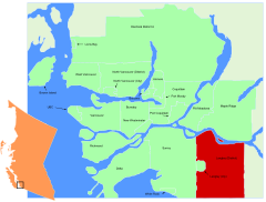
 Location in the Metro Vancouver area |
||
The district of Langley (also Township of Langley ) is an administrative unit of the type of a municipal district in the Canadian province of British Columbia . It belongs to the Metro Vancouver regional district and is bounded by the Fraser River to the north and the border with the United States to the south. In the west it encloses the city of Langley and borders on Surrey , in the east it joins Abbotsford in the regional district of Fraser Valley .
In the district is the historic Fort Langley fur trading post of the Hudson's Bay Company from 1827, which was the first inland settlement on what is now Canada's Pacific coast and in which the establishment of British Columbia was proclaimed in 1858. The present-day village of the same name and other settlements developed around the post, the largest of which was known as Langley. It was founded in 1955 as an independent city from the district.
Demographics
The 2011 census showed a population of 104,177 people in the metropolitan area. The population in the metropolitan area increased by 11.2% compared to the 2006 census, while the population in British Columbia only grew by 7.0%.
Web links
Individual evidence
- ↑ Statistics Canada (2011 Census). Langley District municipality Profile , accessed July 17, 2012
