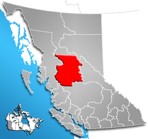
Regional District of Bulkley-Nechako
| Bulkley nechaco | |
|---|---|
 Location of the region in British Columbia
|
|
| Basic data | |
| Country | Canada |
| province |
British Columbia
|
| Administrative headquarters | Burns Lake |
| Coordinates : | 54 ° 30 ′ N , 125 ° 40 ′ W |
| Residents | 37,896 (as of 2016) |
| surface | 73,361 km² |
| Population density | 0.5 inhabitants / km² |
| Time zone : | Pacific Standard Time ( UTC −8) Pacific Daylight Time ( UTC −7, daylight saving time) |
| Web presence | www.rdbn.bc.ca |
The Regional District of Bulkley-Nechako is a district in the Canadian province of British Columbia . It is 73,361 km² and has 37,896 inhabitants (2016). In the 2011 census, 39,208 residents were identified. The borough's main town is Burns Lake . The main industries of the region today are forestry and tourism, while most of the towns were founded for mining.
Administrative structure
cities and communes
| place | status | population |
| Smithers | Town | 5401 |
| Vanderhoof | District municipality | 4439 |
| Houston | District municipality | 2993 |
| Burns Lake | Village | 1779 |
| Fort St. James | District municipality | 1598 |
| Telkwa | Village | 1327 |
| Fraser Lake | Village | 988 |
| Granisle | Village | 303 |
Unregulated areas
- Bulkley-Nechako A.
- Bulkley-Nechako B.
- Bulkley-Nechako C.
- Bulkley-Nechako D.
- Bulkley-Nechako E.
- Bulkley-Nechako F.
- Bulkley-Nechako G.
Web links
- Regional District of Bulkley-Nechako . In: BC Geographical Names (English)
- official page
- Detailed map
Individual evidence
- ^ Census Profile, 2016 Census. November 16, 2017, accessed March 12, 2018 .
- ^ Census Profile, 2016 Census - Provincial Data. August 9, 2019, accessed September 27, 2019 .