Fraser-Fort George Regional District
| Fraser Fort George | |
|---|---|
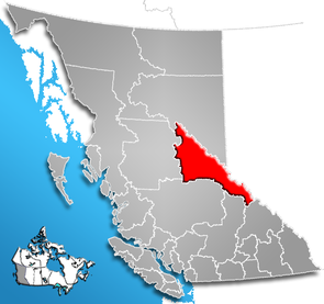
 Location of the region in British Columbia
|
|
| Basic data | |
| Country | Canada |
| province |
British Columbia
|
| Administrative headquarters | Prince George |
| Coordinates : | 54 ° 8 ′ N , 121 ° 46 ′ W |
| Residents | 94,506 (as of 2016) |
| surface | 50,676.10 km² |
| Population density | 1.9 inhabitants / km² |
| Time zone : | Pacific Standard Time ( UTC −8) Pacific Daylight Time ( UTC −7, daylight saving time) |
| Web presence | www.rdffg.bc.ca |
The Fraser-Fort George Regional District is a district in the Canadian province of British Columbia . It is 50,676.10 km² and has 94,506 inhabitants (2016). In the 2011 census, 91,879 inhabitants were determined. The main town is Prince George .
Administrative structure
cities and communes
| place | status | population |
| Prince George | City | 74.003 |
| Mackenzie | District municipality | 3.714 |
| McBride | Village | 616 |
| Valemount | Village | 1,021 |
Unregulated areas
- Fraser-Fort George A (Salmon River & Lakes)
- Fraser-Fort George C (Chilako River-Nechako)
- Fraser-Fort George D (Tabor Lake-Stone Creek)
- Fraser-Fort George E (Woodpecker-Hixon)
- Fraser-Fort George F (Willow River-Upper Fraser)
- Fraser-Fort George G (Crooked River-Parsnip)
- Fraser Fort George H (Robson Valley Canoe)
Web links
Individual evidence
- ^ Census Profile, 2016 Census. November 16, 2017, accessed March 12, 2018 .
- ^ Census Profile, 2016 Census - Provincial Data. August 9, 2019, accessed August 9, 2019 .