Sunshine Coast Regional District
| Sunshine Coast | |
|---|---|
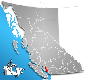
 Location of the region in British Columbia
|
|
| Basic data | |
| Country | Canada |
| province |
British Columbia
|
| Administrative headquarters | Sechelt |
| Coordinates : | 50 ° 0 ′ N , 123 ° 45 ′ W |
| Residents | 29,970 (as of 2016) |
| surface | 3,773.73 km² |
| Population density | 7.9 inhabitants / km² |
| Time zone : | Pacific Standard Time ( UTC −8) Pacific Daylight Time ( UTC −7, daylight saving time) |
| Web presence | www.scrd.bc.ca |
The Sunshine Coast Regional District is a district in the Canadian province of British Columbia . The district borders the Strait of Georgia to the southwest and is 3,773.73 km² in size. It has a population of 29,970 (2016). In the 2011 census, 28,619 inhabitants were determined for the district. It is the third most densely populated district in the province after Metro Vancouver and the Capital Regional District . The main town is Sechelt .
The district is mainly located on a peninsula and cannot be reached on public roads. Transport connections to the mainland are mainly via the ferry connection with BC Ferries from the Langdale Ferry Terminal .
Administrative structure
cities and communes
| place | status | population |
| Gibsons | Town | 4,605 |
| Sechelt | District municipality | 10,216 |
Unregulated areas
- Sunshine Coast A
- Sunshine Coast B
- Sunshine Coast D
- Sunshine Coast E.
- Sunshine Coast F
Web links
Individual evidence
- ^ Census Profile, 2016 Census. November 16, 2017, accessed March 12, 2018 .
- ^ Census Profile, 2016 Census - Provincial Data. August 9, 2019, accessed September 26, 2019 .