Fulmar Bay
| Fulmar Bay | ||
|---|---|---|
|
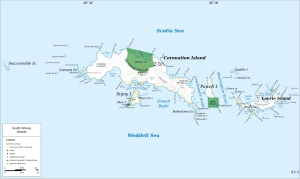
Map of Coronation Island (center) with Fulmar Bay |
||
| Waters | Weddell Sea | |
| Land mass | Coronation Island , South Orkney Islands | |
| Geographical location | 60 ° 36 ′ 58 ″ S , 46 ° 0 ′ 58 ″ W | |
|
|
||
| width | 1.5 km | |
The Fulmar Bay is a 1.5 km wide bay at the west end of Coronation Iceland in Archipelago of the South Orkney Islands . It lies between Moreton Point in the north and Return Point in the south.
The British whaling captain George Powell (1794-1824) and his American counterpart Nathaniel Palmer made a rough map of the coast around this bay in December 1821. It was measured in 1933 by participants in the British Discovery Investigations . The UK Antarctic Place-Names Committee named it in 1954 after the silver petrel ( Fulmarus glacialoides ), whose breeding grounds include the bay's shore.
Web links
- Fulmar Bay in the Geographic Names Information System of the United States Geological Survey (English)
- Fulmar Bay on geographic.org (English)

