
Galičica
| Galičica Mountains | ||
|---|---|---|
 View from the Sveti Naum monastery on Lake Ohrid |
||
| Highest peak | Magaro ( 2255 m. Y. Y. ) | |
| location | North Macedonia | |
|
||
| Coordinates | 40 ° 57 ′ N , 20 ° 48 ′ E | |

The Galičica Mountains ( ) rise in the southwest of North Macedonia between the Ohrid and Prespa lakes .
Its ridge runs roughly in a north-south direction, starting near the city of Ohrid to the Albanian border, where it merges south into the Mali i Thatë mountain range .

The highest point, the Magaro , is 2255 meters high.
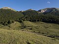
The densely forested mountains in the central areas have been protected as a Macedonian National Park since 1958 .
The Galičica National Park extends to the banks of the two large lakes and covers an area of 22,750 hectares . (241.51 km²) Like the Prespa National Park in Albania bordering to the southeast, it is assigned to IUCN Category II.
During the First World War , the Salonika Front between the troops of the Entente and the Central Powers ran through the Galičica Mountains from 1916 to 1918 .
Web links
photos
Passover

Mountain landscape

Dry meadows in summer

View from Galičica to Lake Ohrid


Individual evidence
- ↑ a b Galicica National Park - Introduction. Retrieved March 8, 2011 .
- ^ National Park. In: Ohrid at your fingertips. Retrieved March 8, 2011 .
- ↑ Michael R Appleton, UNDP-GEF, Ministry of Environment and Physical Planning of the Republic of Macedonia: Protected Areas in Macedonia - An Overview. (PDF) (No longer available online.) 2008, formerly in the original ; Retrieved March 8, 2011 . ( Page no longer available , search in web archives ) Info: The link was automatically marked as defective. Please check the link according to the instructions and then remove this notice.
- ↑ a b World Database on Protected Areas - Galichica National Park (English)