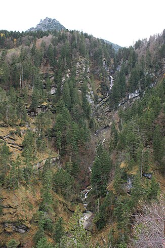
Gampfall
| Gampfall | ||
|---|---|---|
|
On the right the Gampfall which falls in several cascades. Left in the background the corner head |
||
| Coordinates | 47 ° 9 '32 " N , 9 ° 40' 57.2" E | |
|
|
||
| place | Vorarlberg , Austria | |
| Falling watercourse | Gampbach | |
| Estuarine waters | Meng → Ill → Alpine Rhine → North Sea | |
The Gampfall is the most important steep step of the Gampbach . The Gampbach falls here over a length of around 700 meters as the crow flies in several stages over a height of around 500 meters before it flows into the Meng in the Gamperdonatal / Mengschlucht (Meng river kilometers 5.51, at around 765 m above sea level ) . The Gampfall is around 3.5 km as the crow flies southwest of the center of the market town of Nenzing in Vorarlberg ( Austria ). The Gampfall is a natural monument.
origin
The Gampbach rises below the Mattlerjoch ( 1867 m above sea level ), has a total length of 6.51 kilometers and flows over several steep steps into the Meng. The path of the Gampbach and the steep step of the Gampfall were founded due to the susceptibility to erosion of the interglacial gravel deposits located here (so-called: Bürser conglomerate ). In addition, the Ice Age main glacier in the Gamperdonatal was able to deepen further than in the Gamptal , which is why this significant steep step was created at the exit of the Gamptal.
hike
The Gampfall can best be viewed in its entirety from the Buderhöhe viewpoint, which branches off a footpath from the Gamperdonaweg . The Gamperdonaweg is generally closed to public transport from the Stellfeder toll booth (taxi services are offered). It is a 30 to 45 minute walk from the Stellfeder toll booth to the Gampfall.
The Gampfall and the Gampbach as well as the Meng / Mengschlucht are not freely accessible in this area. The Jagdhaus Triegel ( 1144 m above sea level ) is located about 200 meters as the crow flies from Gampfalls to the north . The Gampfall is dominated by the Eckskopf ( 1563 m above sea level ) to the south .
Web links
Individual evidence
- ^ Walter Krieg, Rudolf Alge: Vorarlberger Naturdenkmale: von Baumgiesen, Höhlen und Teufelssteinen , Hard 1991, Hecht-Verlag, ISBN 3-85430-151-0 , p. 163.
- ↑ See also information on the information board at the Buderhöhe viewpoint.
- ↑ 29 Gamptal , website Land Vorarlberg, p. 240.


