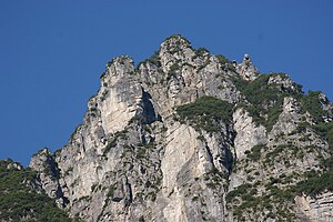
Corner head
| Corner head | ||
|---|---|---|
|
Eckskopf seen from the Gamperdonaweg. |
||
| height | 1563 m above sea level A. | |
| location | in the market town of Nenzing in Vorarlberg , Austria | |
| Mountains | Rätikon | |
| Dominance | 0.05 km → adjacent mountain ridge | |
| Notch height | 40 m ↓ notch to the adjacent ridge | |
| Coordinates | 47 ° 9 '8 " N , 9 ° 40' 52" E | |
|
|
||
| Type | Ledge | |
| rock | Main dolomite , plaster of paris | |
| Age of the rock | approx. 230–200 million years ago | |
|
Situation map of the Rätikon |
||
The Eckskopf (also: Eggskopf , 1563 m above sea level ) is a mountain in the Rätikon , which is located in the municipality of the market town of Nenzing ( Vorarlberg , Austria ).
Surname
The name of the corner head is derived from its location. The mountain is surrounded on three sides by incisions, so it is located "in the corner" - to the south and south-east the Eckskopf falls to the Gamperdonatal (with the Meng / Mengschlucht ), north and northeast to the Gamptal (with the Gampbach ). In the east, the Gampbach cut deep into the rock (this is also where the Gampfall is located ). The mountain owes its striking, protruding appearance to this fact.
location
Seen in the direction of Nenzing, the Eckskopf is one of the last prominent peaks of a part of the northeast running tributary ridge of the so-called Galina group (mountain ridge). The main ridge of the Galina group runs from the Galinakopf ( 2198 m above sea level ) to the Gurtisspitze ( 1778 m above sea level ) and then ends at the Stutzberg near Frastanz . This side ridge of the Galina group , to which the Eckskopf belongs, runs roughly parallel to the Gamperdonatal (on the west side) or Mengschlucht and ends before Nenzing. This side ridge also forms the watershed between the Gamptal and the Gamperdonatal. The mountain ridge that runs parallel to the Gamperdona Valley (east side of the Gamperdona Valley) is the Fundel Group , which also belongs to the Rätikon. The Eckskopf is the northernmost peak between the Gamptal and the Gamperdonatal.
The Gamperdonatal itself can be roughly divided into three valley sections. The outermost section begins at Nenzing in a south-easterly direction. At the Eckskopf, the Gamperdonatal makes an arc and continues in a south-westerly direction. The middle section of the valley begins here at the Eckskopf. The valley basin of the Nenzing sky then forms the inner section to the south.
The Eckskopf is about 750 meters as the crow flies from the Tälispitz (about 1836 m above sea level ) and the Schattatälispitz ( 1937 m above sea level ) to the southwest . The Gampbach with the Gampfall flows northeast about 1300 meters away into the Meng . Kühbruck ( 937 m above sea level ) is located around 1000 meters southeast under the corner head.
Geological situation of the corner head
The corner head and the surrounding area are geologically highly unstable. Several factors are decisive for this instability:
- Due to ice age erosion by the Gamperdonatal and Gamptal glaciers, the Eckskopf was already overstated and therefore unstable after the glaciers (the supporting ice masses) had melted,
- through the further cuts of the Gamperdona valley and the Gamptal valley by the waters flowing here, the terrain was deepened further, which further destabilized the slopes,
- there is a profound divergence of the rocks (main dolomite) on a sliding layer of gypsum . The plaster of paris was partially dissolved by the penetration of water, creating sliding surfaces,
- the main dolomite is very fissured and prone to frost effects . This further promotes rock disintegration.
- deep draft cracks and the disintegrating rock on the sliding layer leads to a deep slope instability,
As a result, large collapse dolines have already formed at the head of the corner and numerous tensile cracks have occurred (some 40 m wide, 400 m long and 150 m deep).
legend
The shadow valley lies under the head of the corner. A hunter should the previously without the high Women's Day (August 15) fair to have visited here on the chamois hunting have gone. A coal-black, powerful buck and a whole pack of chamois are said to have attacked him, so that he had to flee. The hunter thought the black goat was the devil , so he climbed on a fir tree and did not dare to shoot. Only in the late evening did the animals run away and the hunter could go home again.
Web links
Individual evidence
- ↑ 29 Gamptal , website Land Vorarlberg, p. 240.
- ↑ Arie C. Seijmonsbergen, Matheus GG De Jong, Leo WS de Graaff, Niels S. Anders: geodiversity of Vorarlberg and Liechtenstein - geodiversity of Vorarlberg ... , f p 69th
- ↑ 28 Gamperdonatal , website Land Vorarlberg.
- ↑ See Arie C. Seijmonsbergen, Matheus GG De Jong, Leo WS de Graaff, Niels S. Anders: Geodiversity of Vorarlberg and Liechtenstein - Geodiversity of Vorarlberg ... , pp. 64, 69 f.
- Jump up to the hunt without mass , source: Richard Beitl , Im Sagenwald, Neue Sagen aus Vorarlberg , 1953, No. 286, p. 166.


