Chamois plan
| Chamois plan | ||
|---|---|---|
|
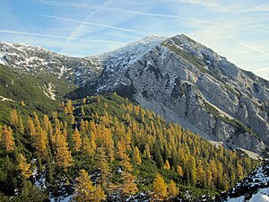
View from the Hagler to the west side of the Gamsplan |
||
| height | 1902 m above sea level A. | |
| location | Upper Austria , Austria | |
| Mountains | Sengsengebirge , Upper Austrian Prealps | |
| Coordinates | 47 ° 46 '27 " N , 14 ° 20' 4" E | |
|
|
||
| rock | Wetterstein lime | |
The Gamsplan , which is also called Merkenstein or Großer Hengst in old sources, is 1902 m above sea level. A. the second highest point in the Sengsengebirge . The western slope is moderately steep in the Upper Knödelboden , while the summit breaks off to the north and south with steep rocky and craggy flanks. To the east, the Gamsplan is connected to the eastern peaks of the Sengsengebirge by a narrow ridge. Only unmarked paths lead to the rarely visited summit.
literature
- Wolfgang Heitzmann, Otto Harant: Upper Austrian Pre-Alps. A ÖAV guide through the mountains south of Linz, Wels and Steyr. 3. Edition. Ennsthaler Verlag, Steyr 1996.

