Gan (Atoll Addu)
| Gan (Atoll Addu) | ||
|---|---|---|
| NASA : Gan (Atoll Addu) | ||
| Waters |
Lakkadive Sea (Indian Ocean) |
|
| Archipelago | Addu Atoll ( Maldives ) | |
| Geographical location | 0 ° 41 '2 " S , 73 ° 7' 59" E | |
|
|
||
| surface | 2.256 1 km² | |
| Residents | 1104 489 inhabitants / km² |
|
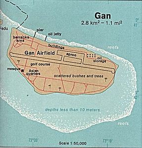
| Map of Gan (Atoll Addu) | ||
Gan ( Dhivehi ގަން) is the southernmost island in the Maldives . It belongs to the Addu Atoll and is about 40 nautical miles (≈77 km) south of the equator .
geography
The island of Gan is located on the Lakkadive Sea . With the southeast coast it touches the Arabian Sea . At their southernmost point, the Arabian Sea in the west, the Laccadive Sea in the east and the Indian Ocean in the south meet.
Gan has Gan International Airport .
| Gan - Addu Atoll | ||||||||||||||||||||||||||||||||||||||||||||||||
|---|---|---|---|---|---|---|---|---|---|---|---|---|---|---|---|---|---|---|---|---|---|---|---|---|---|---|---|---|---|---|---|---|---|---|---|---|---|---|---|---|---|---|---|---|---|---|---|---|
| Climate diagram | ||||||||||||||||||||||||||||||||||||||||||||||||
| ||||||||||||||||||||||||||||||||||||||||||||||||
History and overview
Gan used to be the base of the British Air Force Royal Air Force ( RAF Gan ), and was mainly used as a stopover for aircraft en route to Singapore . From there, sounding rockets of the type Kookaburra and Skua were also launched between 1969 and 1972 .
A special feature of the Addu Atoll is the possibility of moving overland over dams between the islands of the atoll. The inhabitants, especially the women, mainly work in textile processing, or in other atolls in the tourism sector, which is why fathers often do not see their families for long periods of time, as traveling to and from work is tedious and correspondingly expensive in terms of income there.
The former British officers' quarters on Gan have been converted into the Equator Village holiday complex . Unlike other such systems, however, this one on Gan is only part of the local development. On Gan you can find z. B. normal shops with articles of daily use, a small mosque and also a post office. Local Maldivians also live directly on Gan. Presumably the buildings they lived in were formerly British barracks. On a neighboring island you will find a typical settlement, closely built up with small, very spartan huts.
Web links
- Facts about Gan. Malediven.net
- Photo collection Gan / Addu Atoll with pictures above and below water
- Diverland dive center with information about diving in the Addu Atoll
Individual evidence
- ^ Limits of Oceans and Seas . (PDF) International Hydrographic Organization. 3rd Edition. Monte Carlo 1953. 39.- Arabian Sea, 42.- Laccadive Sea
- ^ Gan Island in the Encyclopedia Astronautica , accessed April 16, 2014.

