Geddington
| Geddington | ||
|---|---|---|
| Coordinates | 52 ° 26 ′ N , 0 ° 41 ′ W | |
| OS National Grid | SP8983 | |
|
|
||
| Residents | 1504 (as of 2001) | |
| administration | ||
| Post town | KETTERING | |
| ZIP code section | NN14 | |
| prefix | 01536 | |
| Part of the country | England | |
| region | East Midlands | |
| Shire county | Northamptonshire | |
| District | Borough of Kettering | |
Geddington is a civil parish on the A43 road in the Borough of Kettering on the River Ise in northeast Northamptonshire between Kettering and Corby , 111 km north of London .
population
Geddington had 1504 inhabitants according to the 2001 census.
history
The place owned a royal hunting estate that was used for hunts in Rockingham Forest, but has since gone. However, the Maria Magdalenenkirche still has a "Kings' Door".
Attractions
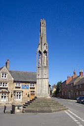
- The best-preserved Eleanor Cross from 1294 is in Geddington .
- The Maria Magdalenenkirche goes back to the 12th to 14th centuries.
- The medieval bridge over the River Ise was built in 1250.
Individual evidence
Web links
Commons : Geddington - collection of images, videos and audio files


