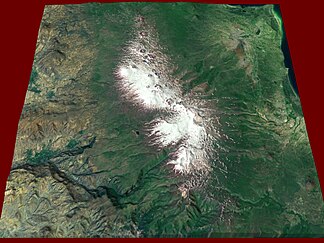
Gegham Mountains
| Gegham Mountains | ||
|---|---|---|
| Highest peak | Ashdahak ( 3597 m ) | |
| location | Armenia | |
| part of | Armenian highlands | |
|
|
||
| Coordinates | 40 ° 12 ′ N , 44 ° 57 ′ E | |
|
Satellite image |
||
|
Lake at Ashdahak summit |
||
The Gegham Mountains (also Geghama Mountains ; Armenian Գեղամա լեռնաշղթա ) is a mountain range in Armenia .
The Gegham Mountains belong to the Armenian Highlands and extend west of Lake Sevan in a north-south direction. It reaches a maximum height of 3597 m in the Ashdahak . The mountains consist of tuff and lava rock . It has several extinct volcanoes . The slopes are covered by a mountain heather landscape.
Mountains (selection)
Below are a number of peaks along the main ridge of the Gegham Mountains, sorted from north to south:
![]() Map with all coordinates: OSM | WikiMap
Map with all coordinates: OSM | WikiMap
Web links
Commons : Gegham Mountains - Collection of images, videos and audio files
Individual evidence
- ↑ a b c Article Gegham Mountains in the Great Soviet Encyclopedia (BSE) , 3rd edition 1969–1978 (Russian)


