
Lake Sevan
| Lake Sevan | ||
|---|---|---|

|
||
| Lake Sevan seen from space (about northwest in the picture above) | ||
| Geographical location | Armenia | |
| Tributaries | Artschitschi, Masrik, Gawaraget, Dsknaget, Pambak | |
| Drain | Hrasdan | |
| Data | ||
| Coordinates | 40 ° 19 ′ N , 45 ° 21 ′ E | |
|
||
| Altitude above sea level | 1900 m | |
| surface | 1 272 km² | |
| length | 78 km | |
| width | 56 km | |
| volume | 33.2 km³ | |
| Maximum depth | 79.7 m | |

|
||
| Change in the water level of Lake Sevan in the 20th century | ||

The Sevan ( Armenian Սեւանա լիճ Sewana Litsch ) is square kilometers with 1272, face, a length of 78 km and a width of a maximum of 56 km, the largest freshwater Armenia and the entire Caucasus . The lake is 1900 m above sea level (as of the end of February 2015), a maximum of 79.7 m deep (October 2010) and its volume is 37.9 km³ (as of 2014).
location
Lake Sevan is located in the Gegharkunik province in eastern Armenia, not far from the border with Azerbaijan . The lake, located in the Sevan Basin , is surrounded by the Sevan Mountains running to the north, which belong to the Lesser Caucasus , as well as the Eastern Sevan Mountains in the east, the Wardenis Mountains in the south and the Gegham Mountains in the west. The coastal plain is up to 17 km wide in the southeast. Grain and fruit are grown there. The Artaniš and Noratuz peninsulas divide the lake into the “Great Sevan” in the southeast and the “Little Sevan” in the northwest. The lake has 28 tributaries, including the Artschitschi , Masrik , Gawaraget , Dsknaget and Pambak . Its only outflow is the Hrasdan , which drains into the macaws through a channel .
climate
The average annual rainfall is 350 mm on the lake itself, 350–446 mm in the coastal plain. The potential natural vegetation of the coastal plain is feather grass steppe. The predominant soils are mountain Kastanozems .
fauna
Five species of fish are found in the lake, three of which are indigenous (the Sevan trout ( Salmo ischan Kessi ), Varicorhinus capoeta seirange and Chalcalburnus tarichi ). By the end of the 1980s, the presumably extinct Armenian bearded bat ( Myotis hajastanicus ) was found in the valley of Lake Sevan .
An important colony of the Armenian gull, comprising more than 10,000 pairs, breeds at the lake .
Research history
Waldemar Belck visited Lake Sevan at the end of the 19th century. In 1906 Lalayan excavated the Bronze Age cemetery at Zowak . In 1926 the first cast of the Urartian inscription was made by Zovinar .
history
The region around Lake Sevan is steeped in history: Elaborate burial sites from the Bronze Age were discovered. The Urartians may have given the lake its name. The Urartian word Ṣue ( ab ṣue) means sea. Argišti I. reached Lake Sevan in his 5th year of reign (782). The inscription from Lchašen. reports that he conquered the land of Qihu and reached the city of Ištiquni. From the first year of his reign, Sarduri II led several campaigns to Lake Sevan and conquered the southeastern shore of the lake, Likiu, Uelikuḫi, Tulihu and Uduri-Etiuni and countries south of the Wardenis Mountains, Ediani, Irduani and Puinialḫi. After the death of Sarduri, the conquests on Lake Sevan were probably lost again. Rusa I. boasts of the victory over 23 countries and 19 kings "from the other side of the lake, in the terrible mountains" ( rock inscription by Zovinar ). After Rusa I. the written records break off. Burney assumes that the area regained its independence, Salvini assumes a Urartean rule until the time of Rusa II and assumes that he ceded the area to the Scythians . Scythian finds from the area of Lake Sevan are, however, sparse and are limited to the fragment of an Akinake from Geghhowit and two arrowheads from Kartschaghbjur and Astghadzor
In Persian times, Lake Sevan was part of Armenia. Eight Aramaic inscriptions of Artaxias I were found in the valley of Lake Sevan , mostly on the fertile south bank. In the Middle Ages, the capital cities were Tsar ( Airk ) and Kot (Geghakuni). From ancient Armenian royal and princely families which many testify to the lake built churches and monasteries, as Sevanavank and Hayrawank . The basin had been largely depopulated since the 17th century. After the Peace of Adrianople in 1829, Armenians from Beyazıt settled in the area. The Turkish name of Lake Sevan is "Gökcay", which means "sky-blue water". In older literature, the Turkish-based spelling Gokcha or the Latin name Lychnitis often appears.
environmental issues
The enormous expansion of the arable land in the Armenian SSR required extensive irrigation measures. Lake Sevan, around twice the size of Lake Constance , is the only large water reservoir in the South Caucasus. It was exploited for large-scale irrigation programs from 1936 and its level sank by 22 m by 1988. The basis for the plan to use the lake for irrigation was, among other things, a memorandum written in 1910 by the engineer Sukias Manasserjan . Another factor was the use of the water from the Sevan river, the Hrasdan, to generate electricity, with a hydropower plant cascade built there . In the 1980s, the lake threatened to lose its ecological balance completely.
Vorotan-Arpa-Sevan Lake tunnel system
From 1961 to 1981 a 48.3 km long tunnel was built through which water was diverted from a reservoir at Ketschut below Jermuk, fed by the Arpa River, to Lake Sevan at Arzwanist . The tunnel was not put into operation until 1988. Since it was foreseeable that the water to be fed in would stabilize the level of the lake, but would not raise it significantly, the construction of another 21.6 km long tunnel through the water began as early as 1981 from the Spandarjan reservoir on the Worotan, which runs even further south, above Sissian, it should first be fed into the Ketschut reservoir and from there further into the Sevan lake. From 1986 the construction work was pushed ahead more actively, but came to a standstill due to the Nagorno-Karabakh conflict between Armenia and Azerbaijan and was temporarily stopped in 1992 after completion of around 18 km due to financial problems. At the end of the 1990s, construction began again. The Worotan-Arpa Tunnel was finally completed in 2003 and put into operation on April 26, 2004. In the period from March 2005 to March 2006, the water level rose by 39 cm to 1,898.15 m above sea level. The increase continued at this rate in the following years. In June 2007 it was announced that the water level had risen by 2.44 m over the past six years. At the beginning of October 2010 the water level was 1900.04 m.
View from Sevanavank Monastery of the lake

Churches of the Sevanavank Monastery on the bank of the lake

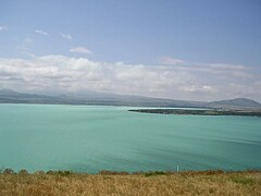
View from the Tbilisi Highway


Web links
- Lake Sevan: Experience and Lessons Learned Brief , 2006 (PDF; 799 kB)
- Article Sevansee in the Great Soviet Encyclopedia (BSE) , 3rd edition 1969–1978 (Russian)
Individual evidence
- ↑ Geographical features and development regularities of rural areas and settlements distribution in mountain countries . In: Annals of Agrarian Science . February 11, 2017, ISSN 1512-1887 , doi : 10.1016 / j.aasci.2017.02.012 ( sciencedirect.com [accessed January 15, 2018]).
- ↑ a b Volume / The total volume, average annual - SEIS Sevan. Retrieved January 15, 2018 .
- ↑ Н. В. Арутюнян, Корпус уратсқих қлинообразных надписеӣ. Ереван, Гитутюн 2001, 462
- ^ Biscione et al., The Armenian-Italian archaeological survey in the Sevan Lake Basin, Campaigns 1994-2000. In: Raffaele Biscione, Simon Hmayakyan Neda Parmegiani (eds.), The North-Eastern frontier Urartians and non-Urartians in the Sevan Lake basin. Rome: CNR, Istituto di studi sulle civiltà dell'Egeo e del Vicino Oriente, 2002, 9-18
- ↑ Г.А. Меликишвили, Урартские клинообразные надписи. Москва: Издательство АН СССР, 1960, No. 134
- ↑ Г.А. Меликишвили, Урартские клинообразные надписи. Москва: Издательство АН СССР, 1960, No. 155
- ↑ Г.А. Меликишвили, Урартские клинообразные надписи. Москва: Издательство АН СССР, 1960, No. 256
- ^ Biscione et al., The Armenian-Italian archaeological survey in the Sevan Lake Basin, Campaigns 1994-2000. In: Raffaele Biscione, Simon Hmayakyan Neda Parmegiani (eds.), The North-Eastern frontier Urartians and non-Urartians in the Sevan Lake basin. Rome: CNR, Istituto di studi sulle civiltà dell'Egeo e del Vicino Oriente, 2002, 12
- ↑ [1]
- ↑ Sevan Rising: Lake Sevan's recovery quicker than expected (June 29, 2007)
- ↑ Սեւանա լճի մակարդակը այս տարի բարձրացել է 56 սանտիմետրով . Radio Free Europe / Radio Liberty , October 6, 2010.