Arpa (river)
|
Arpa Arpaçay |
||
|
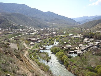
The village of Areni on the banks of the Arpa |
||
| Data | ||
| location | Armenia , Nakhichevan ( Azerbaijan ) | |
| River system | Kura | |
| Drain over | Macaws → Kura → Caspian Sea | |
| Headwaters |
Sangesurkamm 39 ° 57 ′ 11 ″ N , 45 ° 39 ′ 51 ″ E |
|
| muzzle |
Macaw's coordinates: 39 ° 28 ′ 7 " N , 44 ° 56 ′ 48" E 39 ° 28 ′ 7 " N , 44 ° 56 ′ 48" E
|
|
| length | 128 km | |
| Catchment area | 2630 km² | |
| Discharge at the Areni gauge |
MQ |
14 m³ / s |
| Right tributaries | Here | |
| Reservoirs flowed through | Ketchut reservoir | |
| Communities | Jermuk , Areni | |
|
River course and catchment area of the Arpa |
||
The Arpa ( Armenian Արփա ; Azerbaijani Arpaçay ) is a left tributary of the Aras in Armenia and in the to Azerbaijan belonging to the Autonomous Republic of Nakhichevan .
The Arpa rises on the southern flank of the Sangesurkamm in the Armenian province of Vajoz Dzor . It initially flows south. South of Jermuk , the Arpa is dammed up to form the Ketchut reservoir . Later she turns west. It flows 2 km south of the capital of the province, Yeghegnadsor . The river turns south again in the lower reaches and crosses the border to Nakhichevan. Eventually the river reaches the macaws streaming to the southeast.
The Arpa has a length of 128 km. It drains an area of 2630 km².
In 1970 a canal was built that diverts part of the water of the Hrasdan to the Arpa.

