
Armenian highlands
| Armenian highlands | ||
|---|---|---|
 Satellite image of the highlands |
||
| Highest peak | Ararat ( 5137 m ) | |
| location | Armenia , Azerbaijan , Georgia , Iran , Turkey | |
|
||
| Coordinates | 40 ° 31 ' N , 44 ° 12' E | |
 Little and Big Ararat |
||
 Armenian highlands, Achurjan gorges , tributary of the Aras , view from Ani , which has been Turkish since 1921, to the side that has remained Armenian |
||

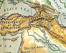
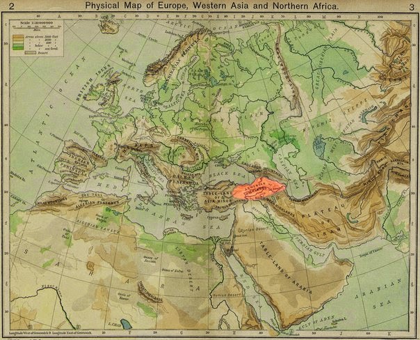
The Armenian Highlands ( Armenian լեռնաշխարհ Հայկական or Բարձր Հայք / Bardsr Hajk), in German also Armenian mountains or Ararathochland called, constitutes the central part of the nordanatolisch northern Iranian- chain mountains , and includes in the broad sense the small Caucasus .
Depending on the definition, the Armenian Highlands are 300,000 to 400,000 square kilometers in size and include areas of Turkey (especially the former Armenian provinces of the Ottoman Empire ), Iran , Georgia , Azerbaijan and almost entirely the present-day Republic of Armenia .
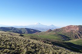
Many mountains in the Armenian highlands represent a series of volcanoes. These include the Jawacheti Mountains , the Arsiani Mountains (Yalnızçam Dağları), the Gegham Mountains and the Haykakan Par (Ağri Dağları). The highest point is the 5137 m high Ararat , an extinct volcano . Large lakes are Lake Van ( salt lake ) and Lake Sevan ( freshwater lake ).
Origin and use of terms
The term is derived from the original settlement area of the Armenians , where ethnogenesis of the Armenian people took place in the middle of the first millennium BC and which was inhabited by Armenians until 1915. As early as the 5th century BC Chr. Was the term in the work " Anabasis " by Xenophon used.
At the beginning of the 20th century, the term Armenian Highlands was familiar to Europeans and North Americans. Sometimes the area was simply referred to as "Armenia" even at that time.
Since the genocide of the Armenians in 1915 and the transformation of Turkey into a mono-ethnic nation state, the term “Armenian highlands” has often been avoided, like other names referring to the indigenous peoples of today's Turkey (for example “Pontic mountain range”). This applies in particular to the language used in Turkey, but also to other countries where the term is not used out of consideration for Turkey. So is the western part of the Armenian highlands, the former Western Armenia , now Eastern Anatolia , although earlier " Anatolia " only western Asia Minor called while the former Eastern Armenia (without the 1921 Treaty of Kars ceded to Turkey areas) with the Republic of Armenia of Transcaucasus region (seen from Russia “behind the Caucasus”) or “ South Caucasus ”. Avoiding the use of the term merely out of consideration for Turkey can be seen as a possible tacit approval of the denial of the Armenian genocide .
Mountain range
Below are some important mountain ranges of the Armenian Highlands:
- Palandöken Dağı
- Bingöl Mountains
- Aladağ
- Karadach
- Mishudag
- Gegham Mountains
- Wardenis Mountains
- Karabakh highlands
- Sangesurkamm
Mountains (selection)
Below are a number of peaks in the Armenian Highlands in a west-east direction:
![]() Map with all coordinates: OSM | WikiMap
Map with all coordinates: OSM | WikiMap
- Ararat ( 5137 m ) ( ⊙ ), Turkey
- Sabalan ( 4811 m ) ( ⊙ ), Iran
- Aragaz ( 4090 m ) ( ⊙ ), Armenia
- Süphan Dağı ( 4058 m ) ( ⊙ ), Turkey
- Kaputjugh ( 3904 m ) ( ⊙ ), Armenia / Azerbaijan
photos
The Armenian Highlands on a map from 1923

View of the Ararat massif
Armenian highlands

At Lake Sevan


literature
- Horst Mensching and Eugen Wirth : Fischer regional studies: North Africa and the Middle East. Frankfurt am Main 1989, pp. 258ff.
- dtv-Perthes World Atlas: Volume 1 - Middle East. Darmstadt 1985, p. 9
- About the geological nature of the Armenian highlands. Festive speech etc., 1843, Wilhelm Hermann ABICH
Web links
The Armenian Highland , video, multilingual
Individual evidence
- ↑ Hofmann, Tessa .: Approaching Armenia: Past and Present . Orig.-issued, 2nd, updated and supplemented edition Beck, Munich 2006, ISBN 978-3-406-54136-0 .
- ↑ Carl von RAUMER (Professor at the University of Erlangen.): Textbook of general geography . 2nd Edition. 1835, p. 211 ( google.am ).
- ↑ a b c Article Armenian Highlands in the Great Soviet Encyclopedia (BSE) , 3rd edition 1969–1978 (Russian)
- ^ A b Tamcke, Martin: Coexistence and Confrontation: Contributions to the recent history and present situation of the oriental Christians . Lit, Münster 2003, ISBN 978-3-8258-6819-2 .
- ↑ Sputnik: Кровавая крепость и Орленок урартского царя: что хранит треугольник армянской цивилизации. Retrieved July 1, 2018 (Russian).
- ↑ Hofmann, Tessa .: Approaching Armenia: Past and Present . Orig.-issued, 2nd, updated and supplemented edition Beck, Munich 2006, ISBN 978-3-406-54136-0 .
- ^ Physical map. Retrieved February 20, 2018 .
- ↑ Map "Europe (physical)". Major C.Loreck, 1913, accessed February 20, 2018 .
- ↑ Tessa Hofmann: Between Ararat and the Caucasus. A portrait of a small country in five key words. In: Huberta von Voss: Portrait of a Hope. The Armenians. Life pictures from all over the world. P. 24. Hans Schiler Verlag, Berlin 2004. ISBN 978-3-89930-087-1 .
- ↑ Wilhelm Hermann ABICH: About the geological nature of the Armenian highlands. Festival speech . 1843 ( google.am ).