Kaputjugh
| Kaputjugh | ||
|---|---|---|
|
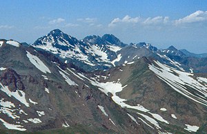
Kaputjugh from the southeast (July 1991) |
||
| height | 3904 m | |
| location | Armenia / Azerbaijan border | |
| Mountains | Sangesurkamm | |
| Coordinates | 39 ° 10 ′ 0 ″ N , 46 ° 0 ′ 30 ″ E | |
|
|
||
| rock | Granite , granodiorite | |
| particularities | highest mountain Nakhchivans, second highest mountain in Armenia | |
The mountain Kaputdschugh ( Armenian Կապուտջուղ , Azerbaijani Qapıcıq dağı , also Kaputdschuch from Russian Капутджух ) is the highest peak of the Sangesurkamm at 3904 m on the border between Armenia ( Sjunik province ) and Azerbaijan ( Autonomous Republic of Nakhchivan ). This makes it the highest mountain in Nakhchivan and the second highest mountain in Armenia.
The mountain massif is slightly glaciated and in places covered with snow all year round. There are a large number of cirques . The Kaputdschuch of the same name , one of the headwaters of the Wochtschi , a left tributary of the Aras, rises on the eastern flank of the mountain . The next highest peaks of the Sangesurkamm, Sissakapar and Parawan (each 3826 m ), connect to the southeast .
To the east of the mountain lies the mining town of Kajaran a good 10 kilometers away on the Armenian side .
Web links
- Sjunik Province website (Armenian, English)
- The Sangesurkamm from: G. Anochin. Maly Kawkas. Moscow, 1981 (Russian)
Individual evidence
- ↑ Product Mount Kaputjugh in the Great Soviet Encyclopedia (BSE) , 3rd Edition 1969-1978 (Russian)

