
Aragaz
| Aragaz | ||
|---|---|---|
 Aragaz with its four peaks |
||
| height | 4090 m | |
| location | Aragazotn , Shirak ( Armenia ) | |
| Mountains | Armenian highlands | |
| Notch height | 2143 m | |
| Coordinates | 40 ° 31 '24 " N , 44 ° 11' 36" E | |
|
||
| Type | Stratovolcano | |
| Age of the rock | Holocene | |
| particularities | highest mountain in Armenia | |

Aragaz ( Armenian Արագած ; also Aragac , Alagyaz ) is an extinct Stratovolcano and 4090 m , the highest peak in Armenia .
The mountain is located on the border of the two provinces of Aragazotn and Shirak, northwest of the capital Yerevan . In addition to the main summit in the north, the west summit with 4080 m , the east summit with 3916 m and the south summit with 3879 m form the jagged crater rim, which remained after the breakup in the Young Pleistocene of the originally 10,000 m high mountain.
The Aragaz is a popular destination for mountain hikers in the summer months. The Bjurakan observatory is located on its southern slope . This observatory was one of the main observatories in the Soviet Union .
In the south of the Aragazotn is Ashtarak , the capital of the province of Aragazotn . After the alternate Armenian name Alagyaz is a village named in the northeast. In the northwest lies the city of Artik , in the southwest the city of Talin .
The Orgow Station, an observation station of the Physics Institute Yerevan for researching cosmic particles, is located near the summit of Aragaz at 3200 m. Lake Kari on the slopes of the volcano is at a similar height .
photos
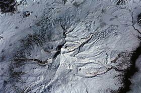
Aerial view with the four peaks


Web links
- Rick Ney: Aragatsotn March . Tour Armenia, 2008, pp. 51-55
- Aragaz in the Global Volcanism Program of the Smithsonian Institution (English)
Individual evidence
- ↑ Article Aragaz in the Great Soviet Encyclopedia (BSE) , 3rd edition 1969–1978 (Russian)