
Aragazotn
| Aragazotn | |
|---|---|
  |
|
| Basic data | |
| Country | Armenia |
| Capital | Ashtarak |
| surface | 2753 km² |
| Residents | 125,539 (2011) |
| density | 46 inhabitants per km² |
| ISO 3166-2 | AM-AG |
| Website | aragatsotn.mtad.am (Armenian) |
| politics | |
| governor | David Geworgjan |
| Political party | independent |
Coordinates: 40 ° 24 ' N , 44 ° 12' E
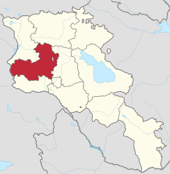
Aragazotn ( [ ɑɾɑɡɑˈt͡sɔtən ] , Armenian Արագածոտնի մարզ , in scientific transliteration Aragacotni marz, in German Province Aragazotn) is a province in western Armenia . The capital of the province is Ashtarak . The name Aragazotn means "at the foot of Mount Aragaz ". In the west the province borders on Turkey .
The province has an area of 2753 km² and a population of 125,539 (as of 2011). A significant minority (over 5% of the population) of Kurdish Yazidis live in the province .
Other cities besides Ashtarak are the earlier urban-type settlements of Aparan and Talin, which were elevated to cities in the 1990s . In addition to these three urban parishes, there are 111 rural parishes with a total of 117 villages; the largest villages (each with over 3000 inhabitants) are Aragazawan (up to the 1990s also urban-type settlement as Aragaz ), Arteni , Bjurakan , Karbi , Oschakan and Woskewas (status 2011).
The province was during the administrative reorganization within the framework of decentralization in 1995 from the 1930/37 since the Armenian SSR of the Soviet Union existing Rajons formed Aparan, Aragats, Ashtarak and Talin and Ashtarak city of rajonfreien.
Web links
- Aragazotn Province in the Armeniapedia (English)
- Official Website (Armenian)
Individual evidence
- ↑ http://aragatsotn.mtad.am/ (accessed January 5, 2020)