
Genkai Quasi National Park
|
Genkai Quasi National Park
|
||
 Hamatama -Beach |
||
| location | Fukuoka , Saga and Nagasaki Prefectures , Kyushu Island , Japan | |
| WDPA ID | 3100 | |
| Geographical location | 33 ° 36 ' N , 130 ° 11' E | |
|
||
| Setup date | June 1, 1956 | |
| administration | Fukuoka Prefecture , Saga Prefecture and Nagasaki Prefecture | |

The Genkai Quasi National Park ( Japanese 玄 海 国 定 公園 , Genkai kokutei kōen ) is one of over 50 quasi national parks in Japan. The park area covers an area of approx. 270 km² and is mainly on the coast of Genkai-Nada, in the prefectures of Fukuoka , Saga and Nagasaki , which are responsible for the administration of the park, which was founded on June 1, 1956. With the IUCN Category V, the park area is classified as a Protected Landscape / Protected Marine Area . The coastal region from the northern part of the city of Karatsu in Saga Prefecture to Imari Bay is known as for its Ria coast and many terraced rice fields. There are also numerous pine forests in the park area. An underwater observatory is located at Cape Hato, the northernmost point of the Higashi-Matsuura Peninsula. The island of Iroha in Imari Bay offers one of the most important viewpoints in the park.
Important landmarks
- Shikanoshima Island ( 志 賀 島 ): Known for the discovery of the gold seal (national treasure) in 1784, which led to the verification of the state of Na . Connected to the country by Uminonakamichi.
- Itoshima peninsula
- Iroha Island: In Imari Bay
gallery

Oura rice terraces and Imari bay
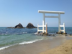
White torii on Futamigaura beach


See also
Web links
World Database on Protected Areas - Genkai Quasi-National Park (English)