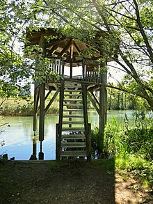
Gerlafingerweiher
|
Gerlafingerweiher Änteweier |
||
|---|---|---|

|
||
| Gerlafingerweiher | ||
| Geographical location | Canton Bern | |
| Tributaries | Tannschachenbach , Strackbach | |
| Drain | Canal to the Emme | |
| Data | ||
| Coordinates | 609 287 / 224067 | |
|
|
||
| Altitude above sea level | 454 m above sea level M. | |
| surface | 0.96 ha | |
| Maximum depth | 0.5 m | |
|
particularities |
Bird sanctuary |
|
The Gerlafingerweiher (also called Entenweiher or Änteweier ) is a lake on the border of the cantons of Bern and Solothurn . It has been under nature protection since 1983.
Location and characteristics
The Gerlafingerweiher is located five kilometers south-southeast of Solothurn near the municipalities of Gerlafingen (Solothurn) and Wiler near Utzenstorf (Bern). Most of it is in the Canton of Bern. As a result of embankments and increasing siltation, the area of the lake decreased from originally 1.8 hectares to only 0.95 hectares. Its catchment area is around 29 hectares, mostly agricultural land (73%) and forest (25%). The lake is located right next to a factory canal and has two separate tributaries: the smaller Tannschachenbach , which flows into the lake from the south, and the canalised Strackbach in the northwest.
Because of its shallow depth of only 0.5 meters, no stable temperature stratification forms in summer, so the lake is continuously saturated with oxygen. The phosphorus concentration is relatively low at around 10 μg / l. Due to the composition of the phytoplankton , which is more typical for eutrophic conditions , it is classified as meso- to eutrophic.
History and use
The lake was formerly in the floodplain of the river Emme , but is a man-made body of water. In 1812/1813 a wood collection warehouse was dug on the site of a pond that had already existed in front of it, which was used to store loosened logs. After the rafting was stopped in 1869, the lake began to silt up. Due to nature conservation concerns, it was initially decided not to contain the siltation, but in 1963 the lake was nevertheless partially dredged. In 1984 it was partially filled in to build a works track. Until 1974, a paper mill discharged sewage into the lake.
The lake offers diverse vegetation, and an alluvial forest developed around it, which provides a habitat for many living beings. The lake is considered a bird sanctuary of national importance, in which breeding birds such as water rail , cuckoo or small woodpecker occur, as well as numerous migrating migratory birds and winter guests. The pond is owned by Von Roll Immobilien AG. Since 1929 the pond has been protected by a contract between Von Roll and the Swiss Society for Ornithology and Bird Protection, and the lake has been a nature reserve since 1983.
There is a six-meter-high observation tower in the area of the municipality of Wiler near Utzenstorf.
Web links
Individual evidence
- ↑ a b c Joachim Guthruf, Katrin Guthruf-Seiler, Markus Zeh: Small lakes in the canton of Bern. Water and Soil Protection Laboratory of the Canton of Bern, Bern 1999, p. 82 f.
- ^ Gerlafinger Weiher , Swiss Society for Ornithology and Bird Protection
- ↑ Gerlafingerweiher. Berner ALA, 2016, accessed August 26, 2016 .
- ^ Extract from the minutes of the government council. Canton of Bern, March 2, 1983, accessed on August 26, 2016 .

