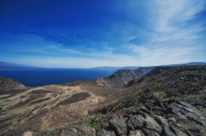
Ghoubbet-el-Kharab
| Ghoubbet-el-Kharab قبة الخراب (Arabic) |
||
|---|---|---|
| Waters | Gulf of Tadjoura, Gulf of Aden | |
| Land mass | Africa | |
| Geographical location | 11 ° 32 ' N , 42 ° 36' E | |
|
|
||
| width | 11 km | |
| length | 205 km | |
| surface | 158 km² | |
| Islands | Ginni Kôma , Abou Maya , Île Parrot | |
| Tributaries | Galeyta, Ana'lé, Afaï, Gala'alé, Dâba le Kakhari, Ḏâḏîn, Fâfêl Madow, Hadaḏléï, Ḏaḏîn, 'Iye, Ḏagabléï, Ḏagaẖweyn, Hiḏsagâro, Ḏasaïnaléï | |
Ghoubbet al-Kharab (Ghoubet al Kharab Arabic قبة الخرابQubbat al-Ḫarāb) is a gulf of the Indian Ocean in the Djibouti area , which is separated from the Gulf of Tadjoura by a rapid current. The bay is surrounded by the areas of Tadjoura in the north and Arta in the south. The bay is surrounded by mountains such as the Ardoukoba volcano, which also separates it from Lake Assal . The cliffs are up to 600 m high. At over 200 m, the bay is deeper than the adjacent Gulf of Tadjoura. It is the habitat for many fish and a large number of sharks. Accordingly, fishing plays an important role.
Jacques-Yves Cousteau carried out research in the Gulf on his research trips. The water level of Ghoubbet al-Kharab can be up to a meter above sea level when the tides and wind drive the water into the bay. In Ghoubbet al-Kharab there are two volcanic islands called Devil's Islands .
Surname
The origin of the name is unclear. There are different terms in use, but they cannot be taken as translations: "Devil's Cauldron", "Gulf of Demons", "Navel of the World", "Bottomless Bay".
Other variants in romanization: Ghoubbet el Kharâb, Le Gubbet, Ghoubbat al Kharab, Ghoubbat al Kharâb, Ghoubet Kharab.


