
Gilpin Tramway
| Gilpin Tramway | |||||||||||||||||||||||||||||||||||||||||||||||||||||||||||||||||||||||||||||||||||||||||||||||||||||||||||||||||||||||||||||||||||||||||||||||||||||||||||||||||||||||||||||||||||||||||||||||||||||||||||||||||||||||||||||||||||||||||||||||||||||||||||||||||||||||||||||||||||||||||||||||||||||||||||||||||||||||||||||||||||||||||
|---|---|---|---|---|---|---|---|---|---|---|---|---|---|---|---|---|---|---|---|---|---|---|---|---|---|---|---|---|---|---|---|---|---|---|---|---|---|---|---|---|---|---|---|---|---|---|---|---|---|---|---|---|---|---|---|---|---|---|---|---|---|---|---|---|---|---|---|---|---|---|---|---|---|---|---|---|---|---|---|---|---|---|---|---|---|---|---|---|---|---|---|---|---|---|---|---|---|---|---|---|---|---|---|---|---|---|---|---|---|---|---|---|---|---|---|---|---|---|---|---|---|---|---|---|---|---|---|---|---|---|---|---|---|---|---|---|---|---|---|---|---|---|---|---|---|---|---|---|---|---|---|---|---|---|---|---|---|---|---|---|---|---|---|---|---|---|---|---|---|---|---|---|---|---|---|---|---|---|---|---|---|---|---|---|---|---|---|---|---|---|---|---|---|---|---|---|---|---|---|---|---|---|---|---|---|---|---|---|---|---|---|---|---|---|---|---|---|---|---|---|---|---|---|---|---|---|---|---|---|---|---|---|---|---|---|---|---|---|---|---|---|---|---|---|---|---|---|---|---|---|---|---|---|---|---|---|---|---|---|---|---|---|---|---|---|---|---|---|---|---|---|---|---|---|---|---|---|---|---|---|---|---|---|---|---|---|---|---|---|---|---|---|---|---|---|---|---|---|---|---|---|---|---|---|---|---|---|---|---|---|---|---|---|---|---|---|---|---|---|---|---|---|---|---|---|---|---|---|---|
.jpg) Photo in an advertisement in The Mining Investor dated January 15, 1906
| |||||||||||||||||||||||||||||||||||||||||||||||||||||||||||||||||||||||||||||||||||||||||||||||||||||||||||||||||||||||||||||||||||||||||||||||||||||||||||||||||||||||||||||||||||||||||||||||||||||||||||||||||||||||||||||||||||||||||||||||||||||||||||||||||||||||||||||||||||||||||||||||||||||||||||||||||||||||||||||||||||||||||
 Locomotive shed
| |||||||||||||||||||||||||||||||||||||||||||||||||||||||||||||||||||||||||||||||||||||||||||||||||||||||||||||||||||||||||||||||||||||||||||||||||||||||||||||||||||||||||||||||||||||||||||||||||||||||||||||||||||||||||||||||||||||||||||||||||||||||||||||||||||||||||||||||||||||||||||||||||||||||||||||||||||||||||||||||||||||||||
| Route length: | 26.46 miles = 42.58 km | ||||||||||||||||||||||||||||||||||||||||||||||||||||||||||||||||||||||||||||||||||||||||||||||||||||||||||||||||||||||||||||||||||||||||||||||||||||||||||||||||||||||||||||||||||||||||||||||||||||||||||||||||||||||||||||||||||||||||||||||||||||||||||||||||||||||||||||||||||||||||||||||||||||||||||||||||||||||||||||||||||||||||
| Gauge : | 610 mm ( 2 foot track ) | ||||||||||||||||||||||||||||||||||||||||||||||||||||||||||||||||||||||||||||||||||||||||||||||||||||||||||||||||||||||||||||||||||||||||||||||||||||||||||||||||||||||||||||||||||||||||||||||||||||||||||||||||||||||||||||||||||||||||||||||||||||||||||||||||||||||||||||||||||||||||||||||||||||||||||||||||||||||||||||||||||||||||
| Maximum slope : | 60 ‰ | ||||||||||||||||||||||||||||||||||||||||||||||||||||||||||||||||||||||||||||||||||||||||||||||||||||||||||||||||||||||||||||||||||||||||||||||||||||||||||||||||||||||||||||||||||||||||||||||||||||||||||||||||||||||||||||||||||||||||||||||||||||||||||||||||||||||||||||||||||||||||||||||||||||||||||||||||||||||||||||||||||||||||
.jpg) Route sketch from 1905
| |||||||||||||||||||||||||||||||||||||||||||||||||||||||||||||||||||||||||||||||||||||||||||||||||||||||||||||||||||||||||||||||||||||||||||||||||||||||||||||||||||||||||||||||||||||||||||||||||||||||||||||||||||||||||||||||||||||||||||||||||||||||||||||||||||||||||||||||||||||||||||||||||||||||||||||||||||||||||||||||||||||||||
|
|||||||||||||||||||||||||||||||||||||||||||||||||||||||||||||||||||||||||||||||||||||||||||||||||||||||||||||||||||||||||||||||||||||||||||||||||||||||||||||||||||||||||||||||||||||||||||||||||||||||||||||||||||||||||||||||||||||||||||||||||||||||||||||||||||||||||||||||||||||||||||||||||||||||||||||||||||||||||||||||||||||||||
The Gilpin Tramway was a 1887-1917 run 42.58 km long narrow gauge - mine railway with a track width of 2 feet (610 mm) at Black Hawk and Central City in Gilpin County of Colorado .
history
In April 1859, John H. Gregory went to Clear Creek near Golden to look for gold. After its prospectors found gold flakes, they followed the northern arm of Clear Creek to what is now the Forks . Gregory found large amounts of gold dust in the gorge above Black Hawk, which is now called Gregory Gulch after him. The Gregory Lode was found there.
News of the find spread quickly. As early as September 1859, 900 gold prospectors had settled in log cabins and tents in the valley. In the summer of 1860 sixty ore mills and thirty simple grinders called Arrastra were in operation and the population had grown to 15,000. Numerous mining camps soon sprung up, including Black Hawk, Central City, Nevadaville, Russell Gulch, and Apex.
By the mid-1860s, solid gold had been mined and Gilpin County's prospectors were having tough times. Better processing technology in grinding and a way to move the ore from mine to mill and mill and from there to markets were needed. The new processing technology was introduced with the first smelter built in Black Hawk in 1865. In terms of transport, the narrow-gauge Colorado Central Railroad (CCRR) was built with a track width of 3 feet (914 mm). The CCRR was founded in 1870, construction began in September 1871. The route ran from Golden along Clear Creek to Forks, where it forked, with a branch route leading to Black Hawk. The first train reached Black Hawk on December 15, 1873. From this point on, the mills could bring their products to Denver and from there to other cities. In 1878, a six-mile line was built from Black Hawk to Central City, just 1 mile as the crow flies, and the first train arrived on May 21, 1878.
Gilpin Tramway Company
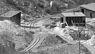
_Gilpin_Tram,_engine_house.jpg)
But it was still dangerous and expensive to bring the gold-bearing quartz ore from the mines in horse-drawn carts to the grinding mills in Central City and Black Hawk. In the summer of 1886, the five miners Henry C. Bolsinger, Bradford Locke, Robert A. Campbell, Andrew W. Rogers and Henry J. Hawley got together to solve the problem. They founded the Gilpin Tramway Company on July 29, 1886 in Central City. The company's goal was to build a 2-foot (610 mm) narrow gauge railway to carry ore from the mines above Black Hawk to the grinding mills.
Construction of the 2-foot narrow-gauge railway
_Gilpin_Tram,_The_Grand_Central_Gold_Mining_Co.jpg)
The leveling of the route began in May 1887. A half-timbered barn was used as a locomotive shed above Black Hawk. The first rails were laid on July 1, 1887. Shay Locomotive No. 1 was delivered on August 26, 1887 and made its first run on September 1, 1887. There was even a passenger train for the residents of Central City, from where the narrow-gauge railway crossed the Eureka Gulch from September 29, 1887 and led to Black Hawk.
The route led down into Clear Creek and from there up along the edge of the hill to Gregory Gulch. The maximum incline was six percent with multiple turns with a radius of 50 feet (15 m). The route continued through Central City. From there it went on to Nevadaville, Quartz Hill and Russel Gulch.
Much of the height gained by the Gilpin Tramway was achieved through the use of switchbacks. The narrow-gauge railway had more switchbacks than any other American railroad. At one point, seven switchbacks were used to reach a single mine.
opponent
The railroad was not without its opponents. The Gilpin Tramway was in direct competition with the various hauliers . Colorado Central had approved the laying of a three-rail track through Black Hawk to enable the Gilpin Tramway to reach various grinders and smelters. Mayor William Fick, who was on good terms with many of the carters, fought to keep the Gilpin Tramway from passing through 'his' town. The three-rail track was laid after various legal disputes in December 1887. But in April 1888, the mayor, accompanied by the marshal, forbade the workers to lay further third rails and asked them to remove existing tracks. Fick explained that the narrow-gauge railway is making the carters unemployed, which is a major disaster for the city. But after paying $ 450 to the City of Gilpin, the mayor was advised to end his lost battle, and none of the tracks were removed.
tourism
Ore and supplies weren't the only goods carried on the Gilpin Tramway. On May 23, 1888, the tram received six new excursion passenger cars. As with many other railways in the western United States, tourist traffic was a good addition to the transport volume. Excursions took place every summer. A round-trip from Black Hawk with lunch was 75 cents. A combined trip on Colorado Central from Denver was $ 2.40.
Route extensions
_Gilpin_Tram_in_the_snow.jpg)
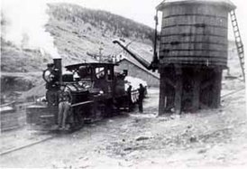
During the whole of 1888, branch lines to other mines and grinding works were laid, so that the route network in the winter of 1888 already had a total length of 25 kilometers (15.5 miles). When winter came there was a new challenge. The ore came from wet ground, and in winter it had a tendency to freeze solid in the railroad cars before it was delivered to the mills. This problem was solved with a unique solution: a warm-up shed with tracks along its entire length was built near the locomotive shed. Steam pipes and furnaces kept the building warm and kept the ore warm and dry.
Sold to the Colorado and Southern Railway
_Gilpin_Tram,_Quartz_Hill_Mine_branch_and_mainline_to_Black_Hawk_in_the_foreground.jpg)
Traffic continued to grow in the 1890s and three more Shays were procured. Occasionally there have been accidents in which locomotives or wagons derailed and overturned. Around 1900, new shays replaced the old ones.
In January 1899, the Colorado Central Railroad (then owned by the bankrupt Union Pacific Railroad ) was taken over by the Colorado and Southern Railway (C&S). The Gilpin Tramway had made an attractive profit by the beginning of the 20th century, so in 1905 the C&S considered taking over it. On June 27, 1906, the Gilpin Tramway was sold to the Colorado and Southern.
Closure of the narrow-gauge railway
In 1910 the Gilpin Tramway network had its greatest length at 42.58 kilometers (26.46 miles) including branches and sidings. The C&S bought the Gilpin Tramway at the height of its profitability. The profit margins for gold mining then declined due to both higher costs for mining the gold and government fixed prices on the gold market. Therefore, the volume of traffic decreased.
As mining progressed, the mines became deeper and deeper, so that pumping out water underground became an increasing problem. After new drilling techniques were introduced, horizontal transport tunnels could be built from Idaho Springs , from which the lower levels of many mines in Gilpin County could be reached to drain the troublesome water and extract the ore. Idaho Springs' Newhouse Tunnel was the first and most important to enter the mines.
While in 1913 a profit of $ 10,238 was recorded, the narrow-gauge railway made a loss of $ 9,750 in 1914. The trend continued in 1915 when the narrow-gauge railroad lost $ 10,437. After the Gilpin Tramway went into the red, the last train left on January 17, 1917. The railroad was sold for scrapping shortly thereafter in June 1917.
Locomotives
| number | photo | Manufacturer | Type | Construction year | Serial number | Remarks |
|---|---|---|---|---|---|---|
| 1 |
_Gilpin_Tram,_Shay_locomotive.jpg) Shay # 1, Gilpin |
Lima Locomotive Works | 10 t Shay | August 1887 | 181 | 1905 as their no. 1 in Silver City, Pinos Altos and Mogollon Railroad sold |
| 2 |
 Shay # 2, Russell |
Lima Locomotive Works | 12 tons of shay | February 1888 | 199 | 1905 sold as their No. 2 to Silver City, Pinos Altos and Mogollon Railroad |
| 3 |
_Gilpin_Tram,_Shay_No_3_in_front_of_the_engine_house_in_Black_Hawk.jpg) Shay # 3, Quartz Hill |
Lima Locomotive Works | 15 t Shay | December 1889 | 264 |
_Gilpin_Tram,_wreck_of_Shay_No_3_at_Prosser_Gulch.jpg) Derailed at the Prosser Gulch in 1897. Scrapped in 1938. |
| 4th |
 Shay # 4 |
Lima Locomotive Works | 17 t Shay | January 1900 | 594 | Scrapped in 1938 |
| 5 |
_Gilpin_Tram,_Shay_No_5.jpg) Shay # 5 |
Lima Locomotive Works | 18 t Shay | April 1902 | 696 | Scrapped in 1938 |
dare
| number | photo | Manufacturer | Type | Construction year | length | Remarks |
|---|---|---|---|---|---|---|
| 1-5 |
_Gilpin_Tram,_Shay_No_1_with_work_train_in_front_of_the_Meade_Mill.jpg) Work train with flat car |
Flat car | 1888 | 17 ft (5.20 m) | No. 3 was converted into coal wagon No. 14 | |
| 6-13 | Coal wagon | 1888 | 17 ft | |||
| 14-17 | Coal wagon | 17 ft | ||||
| 18-37 |
_Gilpin_Tram,_The_Patch_atop_Quartz_Hill.jpg) First generation with locking bars |
Lima Locomotive Works | Ore wagon | 1887 | 17 ft 7 in (5.36 m) | Originally 1⁄2 cord (1.8 m³) loading volume converted to 3⁄4 cord (2.7 m³) |
| 38-87 |
_Gilpin_Tram,_new_ore_car_at_the_Lima_factory.jpg) New ore wagon at the Lima Locomotive Works |
Lima Locomotive Works | Ore wagon | 1888 | 17 ft 7 in | 1 cord (3.6 m³) loading volume |
| 88-155 |
_Gilpin_Tram,_trick_photo_with_the_same_man_in_3_positions.jpg) Trick photo with the same man in 3 places |
Lima Locomotive Works | Ore wagon | 1889 | 17 ft 7 in | 1 cord loading volume |
| 300 | Gilpin | Water tanker | 23 ft (7.0 m) | 2,200 US gallons (8,300 L) capacity | ||
| First number 400 |
_Gilpin_Tram,_Caboose_No_400,_at_the_lead_to_the_enginehouse.jpg) Caboose No. 400 |
Gilpin | Caboose | 1904 | 13 ft 2 in (4.01 m) | Destroyed in 1912 |
| Second no.400 | Colorado and Southern Railway | Caboose | 1912 | 14 ft 2 in (4.32 m) | ||
| 401 | Colorado and Southern Railway | Caboose | 1913 | 14 ft 2 in | ||
| 500-505 |
.jpg) Excursion car |
Excursion car | 1888 | 21 ft (6.40 m) | One of them converted into flat car second no. 4; one in 1906 converted into rail and tank car no. 01; one reused in 1913 for parts of Caboose No. 401; the last one with No. 500 was renumbered as No. 1 in 1915 |

Oliver Mill at Chase Gulch
Hairpin at Midas Mill

The Avon Gold Mining Co
Water tower at the Eureka Gulch

Nedaville on Quartz Hill

Tip turn branch to Concrete Mine

Winnebago Hill with three Shay locomotives

Train with 7 cars, caboose and tanker on Winnebago Hill
_Gilpin_Tram,_Oliver_Mill_in_Chase_Gulch,_0.5_mi_above_Black_Hawk.jpg)
_Gilpin_Tram,_Midas_Mill_switchback.jpg)
_Gilpin_Tram,_The_Avon_Gold_Mining_Co.jpg)
_Gilpin_Tram,_Eureka_Gulch_Water_Tank.jpg)
_Gilpin_Tram,_Nevadaville_at_Quartz_Hill_(04).jpg)
_Gilpin_Tram_in_the_snow,_the_Concrete_Mine_switchback_branch_diverges_off_to_the_left.jpg)
_Gilpin_Tram,_Winnebago_Hill_with_3_Shay_locomotives.jpg)
_Gilpin_Tram,_Winnebago_Hill,_train_with_7_loaded_cars_plus_caboose_and_water_tank_car_at_rear.jpg)
Web links
_Gilpin_Tram,_Shay_No_3_on_the_Kansas-Gold_Coin_track_with_Hubert_Mine_of_Vendome_Mining_Co_in_the_background.jpg)
- Keith Pashina: Modeling 'The Gilpin Tram' - Part I
- Keith Pashina: Modeling 'The Gilpin Tram' - Part II
- Mark Baldwin: Gilpin Tram in Central City and Blackhawk
literature
- Ericson, Duane: Silver City Narrow Gauge . M2FQ Publications, 2007.
- Ferrell, Mallory Hope: The Gilpin Gold Tram . Pruett Publishing, 1970, ISBN 0-87108-045-1 .
- Koch, Michael: The Shay Locomotive Titan of the Timber . The World Press, 1971.
Individual evidence
- ^ Colorado and Southern list of Stations, January 1, 1905.
- ↑ Ferrell (1970) pp. 11-19
- ↑ Ferrell (1970) p. 19
- ↑ Ferrell (1970) p. 21
- ↑ Ferrell (1970) pp. 22-25
- ↑ Ferrell (1970) pp. 25-28
- ↑ Ferrell (1970) p. 29
- ↑ Ferrell (1970) pp. 59-64
- ↑ Keith Pashina: Modeling the Gilpin Tram. Part 2, p. 8
- ↑ Keith Pashina: Modeling the Gilpin Tram. Part 2, p. 6
- ↑ a b Koch (1971) p. 388
- ↑ a b Ericson (2007) pp. 24-25
- ↑ Koch (1971) p. 390
- ↑ Koch (1971) p. 401
- ↑ Koch (1971) p. 407
- ↑ Ferrell (1970) p. 100
Coordinates: 39 ° 48 ′ 9.5 ″ N , 105 ° 30 ′ 35 ″ W.