2007 Gisborne earthquake
| 2007 Gisborne earthquake | ||
|---|---|---|
|
|
||
| Coordinates | 38 ° 51 '36 " S , 178 ° 31' 12" E | |
| date | December 20, 2007 | |
| Time | 8:55 p.m. local time | |
| intensity | 8 on the MM scale | |
| Magnitude | 6.7 M L | |
| depth | 40 km | |
| epicenter |
Hikurangi Trough
(50 km southeast of Gisborne )
|
|
| country | New Zealand | |
| Affected places | ||
| Tsunami | No | |
| dead | 1 | |
| Injured | 11 | |
|
|
||
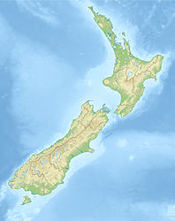
The 2007 Gisborne earthquake occurred on December 20, 2007, 50 km southeast of Gisborne in the Hikurangi Trough of the Pacific Ocean off the east coast of the North Island of New Zealand . The quake had a magnitude of 6.7 M L .
Tectonic background
The earthquake occurred on the line of the so-called Hikurangi Trough , a trough that represents the subduction interface in which the Pacific plate is pushed under the Australian plate . On this line there are also two zones in which so-called slow slip events occur, tectonic movements that do not cause any noticeable earthquakes due to their slowness. From the Tolaga Bay seaward down to Mahia Peninsula is one of them. Movements here can usually only be detected with GPS measurements. Despite the peculiarity of these zones, destructive earthquakes also occur, as happened here in 2007.
The quake
The main quake was felt from Auckland over 1,000 km down to Dunedin . In Gisborne and Napier there was a partial power cut, and there were also problems in the infrastructure of the Internet and telephone connections. The water and sewage pipes and gas connections were partially damaged. Numerous buildings were structurally damaged, three of which in the city did not withstand the quake and collapsed. Lesser damage was reported from Wairoa . No tsunami followed the quake . With a quake of this magnitude and depth, a tsunami would have been unlikely, according to GeoNet .
See also
Web links
- M 6.7, Gisborne, December 20, 2007 . GeoNet - GNS Science,accessed April 7, 2013.
Individual evidence
- ↑ Laura Wallace : The Hikurangi subduction zone: the biggest “unknown” seismic hazard in New Zealand . Ed .: Institute of Geological & Nuclear Sciences . Lower Hutt 2009 (presented on August 11, 2010 at the 4th Australasian Hazards Management Conference, Te Papa, Wellington, New Zealand ).

