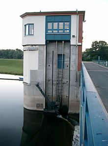
Gnevsdorfer receiving water
The Gnevsdorfer receiving water is an approximately 11 km long canal between the Havel and the Elbe . It is an artificial Havel runoff and serves to relocate the backwater point of the Havel downstream. This flood protection system includes the four weirs at Quitzöbel (old arm and piercing weir ), Neuwerben and Gnevsdorf as well as the Havelberg lock .
The relocation of the backwater point of the Havel
The gradient of the Elbe in the area of the natural mouth of the Havel is approx. 15 cm / km and that of the Havel approx. 4 cm / km. The Elbe has a gradient three to four times as high. The construction of a second mouth near Gnevsdorf brought an increase in the gradient in favor of the Havel flood, which at the same time lowered the backwater level of the Havelniederung.
Because of the low and flat Havelland there are large flood plains. The flood flooded thousands of hectares of fields, pastures and meadows between Bahnitz and Havelberg . While the flooding of the Elbe often receded very quickly, the water in the Havel area often remained on the fields and pastures until summer. This regularly meant considerable crop losses for the farmers. Huge swarms of mosquitoes molested people and animals. In the 1880s and 1890s there were catastrophic floods in the Havelniederung. Then there were complaints from the population. In 1904, based on the complaints, the law to "improve the receiving water and shipping conditions" was drawn up. The aim was to accelerate flood drainage, improve shipping conditions, lower water levels during floods and drain the areas by July 1st each year. Barrages and weirs were also planned.
The life of the population in the lowlands of the Havel and Elbe has always been shaped by floods. The long-lasting floods were not brought about by the Havel, but by the Elbe. The mean water of both rivers is almost the same. The Havel has a water level change between low and high tide of about 2.00 m. The Elbe, however, is about 6.00 m. The water level of the Elbe can therefore be 4.00 m higher than the water level of the Havel. The Havel runoff is no longer guaranteed and the water accumulates. Before the Quitzöbel weir group was built (1938) and the Neuwerben weir (1954), the water in the Havel lowlands often flowed back to Rathenow .
cards
- Folke Stender: Editing of Sportschifffahrtskarten inland 1. Nautical publication Verlagsgesellschaft, ISBN 3-926376-10-4 .
- W. Ciesla, H. Czesienski, W. Schlomm, K. Senzel, D. Weidner: Shipping maps of the inland waterways of the German Democratic Republic 1: 10,000. Volume 4. Editor: Waterways Authority of the GDR, Berlin 1988, OCLC 830889996 .
literature
- Hans-J. Uhlemann: Berlin and the Märkische waterways. Transpress Verlag, Berlin 1987, ISBN 3-344-00115-9 .
- Writings of the Association for European Inland Shipping and Waterways e. V. Various years. WESKA (Western European Shipping and Harbor Calendar), Binnenschifffahrts-Verlag, Duisburg-Ruhrort. OCLC 48960431
- Herbert Stertz: Havel shipping under steam . Economic factor and experience. Media @ Vice, Pritzwalk 2006, ISBN 3-00-019924-1 .
Coordinates: 52 ° 52 ′ 37 ″ N , 11 ° 59 ′ 58 ″ E


