Gopło
| Gopło | ||
|---|---|---|

|
||
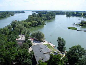
| Gopło with peninsula, seen from the Mouse Tower in Kruszwica | ||
| Geographical location | Greater Poland | |
| Tributaries | Noteć | |
| Drain | Noteć | |
| Places on the shore | Kruszwica | |
| Location close to the shore | Inowrocław | |
| Data | ||
| Coordinates | 52 ° 35 '8 " N , 18 ° 21' 15" E | |
|
|
||
| Altitude above sea level | 77 m | |
| surface | 21.8 km² | |
| Maximum depth | 16.6 m | |
| Middle deep | 4.7 m | |
The Jezioro Gopło (short: Gopło ; German Goplosee , older also Goplersee ) is located in the Polish region of Greater Poland . It extends in a north-south direction and has numerous large islands.
It begins 12 km south of Inowrocław (Eng. Hohensalza ), extends 37 km from north to south and is divided lengthways by a large peninsula. The two arms are no more than 4 km wide. It is traversed by the Noteć (dt. Netze ), which leaves it at Kruszwica (dt. Kruschwitz ). It is connected to the Bydgoski (Bydgoszcz) Canal (Oder-Vistula waterway) by the Netze Canal , which largely uses the bed of the river, and by the Bachorze and Zgłowiącka canals with the central Vistula near Włocławek ( Leslau ) and through the Kanał Warta-Gopła with the upper Warta near Konin .
