Goroubi
| Goroubi | ||
|
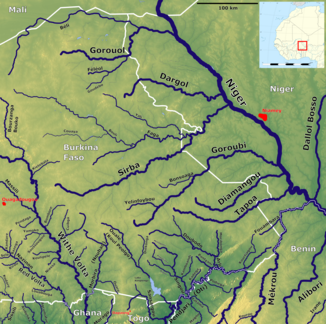
The western Niger tributaries in Niger with the Goroubi (center right) |
||
| Data | ||
| location |
|
|
| River system | Niger | |
| Drain over | Niger → Atlantic | |
| source | in Burkina Faso | |
| muzzle | in Niger coordinates: 12 ° 54 ′ 2 " N , 2 ° 22 ′ 42" E 12 ° 54 ′ 2 " N , 2 ° 22 ′ 42" E |
|
| Mouth height |
176 m
|
|
| length | 433 km | |
| Catchment area | 15,500 km² | |
| Outflow at the Diongore A Eo gauge : 15,350 km² Location: 15 km above the mouth |
MNQ 1962–1967 MQ 1962–1967 Mq 1962–1967 MHQ 1962–1967 HHQ (17.9.1962) |
0 l / s 7.8 m³ / s 0.5 l / (s km²) 44.1 m³ / s 150 m³ / s |
The Goroubi is a seasonal right tributary of the Niger in Burkina Faso and Niger .
course
The river has its source in the north-east of Burkina Faso. It flows in an easterly direction. The Goroubi flows into the Niger River from the right in the Niger.
Hydrometry
Average monthly flow of the Goroubi at the hydrological station Diongore, 15 km from the mouth, measured in m³ / s.

