
Bonstorf burial ground

The Bonstorf Barrows is the remnant of a much larger hill burial ground of late Neolithic or early Bronze Age . It is located east of the village of Bonstorf , a district of Südheide in the Lower Saxony district of Celle . On the burial ground directly on the western edge of the Südheide Nature Park there are five closely adjacent burial mounds.

The largest burial mound was originally in a field adjacent to the north of the still existing barrows. Due to the danger it was excavated in 1973 and reconstructed near the site. The stone constructions found in the hill are interesting. The hill was framed by a stone wreath.
Under the earthfill was a wooden chamber in which a man was buried facing east-west. As grave goods a clay pot and a were Absatzbeil , a sword and a dagger of Bronze found.
In the northern edge of the hill a woman was buried on a stone bed who wore two seven-ribbed bracelets and a headdress made of groups of small bronze tubes. There was also a bronze wheel needle on her chest . It is very likely that the woman had a personal connection with the buried man.
The grave goods found are characteristic of the older Bronze Age (i.e. from around 1500 to 1200 BC) in the Lüneburg Heath .
- Unearthed finds

Clay pot

Bronze heel ax

Bronze dagger
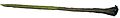
Bronze sword
.JPG)
.JPG)
.JPG)

literature
- EL Voss: A rich burial mound from the older Bronze Age by Bonstorf , Kr. Celle 1975 pp. 59–83
Web links
Coordinates: 52 ° 51 ′ 51 ″ N , 10 ° 3 ′ 53 ″ E