
Bonstorf
|
Bonstorf
community Südheide
Coordinates: 52 ° 51 '43 " N , 10 ° 2' 54" E
|
||
|---|---|---|
| Height : | 66 (61-85) m | |
| Residents : | 530 | |
| Incorporation : | 1st January 1973 | |
| Incorporated into: | Hermannsburg | |
| Postal code : | 29320 | |
| Area code : | 05052 | |
Location of Bonstorf in Lower Saxony |
||

Bonstorf is part of the municipality of Südheide in the northern district of Celle in the Lüneburg Heath .
geography
Bonstorf is about 3 km from the center of Hermannsburg on the border with the Heidekreis district and currently has about 530 inhabitants. In 1973 Bonstorf became part of the unified municipality of Hermannsburg as part of the regional reform in Lower Saxony . The districts of Barmbostel and Hetendorf are part of Bonstorf .
Bonstorf is located on the small brook "Brunau" , which flows north of Hermannsburg into the Örtze .
Agriculture is predominantly practiced in the place. The village image of Bonstorf is characterized by the farmhouses, but also by a relatively large car dealership.
history
To the east of the village are the remains of a burial mound from the late Neolithic or early Bronze Age . The first written mention of Bonstorf can be found in the parish news and dates from 1450. It is about the fact that in the "Bormwiese" , a swampy spring meadow between Backeberg and Bonstorf, a dead man was found who was up to his neck in the swamp stuck. It was believed that the "Elven" , meaning the angry and evil spirits, would have dragged him into it. For this reason, Priest Magnus Lauenrod ordered that the man should not be buried in the churchyard. The next written mention dates from the year 1504. The church book reports that in the course of the Hildesheim collegiate feud on the "Bormwiese" on St. John's Day (June 24th) 1519 (four days before the Battle of Soltau ) a military conflict took place. The Calenberg knight Hans von Ollershusen sank into the mud with his horse and was saved by the knight Hans von Spörcken.
In 1793 Bonstorf received its own school. It was shut down in 1973. Part of the building was sold as a residential building, while another part remained the property of the municipality and is also used as an apartment.
On January 1, 1973 Bonstorf was incorporated into the municipality of Hermannsburg.
In 1995 the only restaurant in town closed. The shop in the same building had previously given up trading.
politics
With the merger of Hermannsburg with the neighboring community of Unterlüß on January 1, 2015, the place became part of the community of Südheide .
The local council of Bonstorf consists of five local council members. Gisela Meyer is the local mayor.
- Attractions
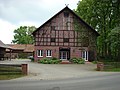
Farm in Bonstorf

War memorial 1914–1918 and 1939–1945

Marsh meadow on the Brunau, between Backeberg and Bonstorf

Listed warehouse

Cutted pollard willows on the Brunau between Bonstorf and Backeberg

Bonstorf burial ground


Web links
Individual evidence
- ↑ An elevation east of the village, between Bonstorf and Backeberg, is still called "Elfenberg" today.
- ^ Federal Statistical Office (ed.): Historical municipality directory for the Federal Republic of Germany. Name, border and key number changes in municipalities, counties and administrative districts from May 27, 1970 to December 31, 1982 . W. Kohlhammer GmbH, Stuttgart and Mainz 1983, ISBN 3-17-003263-1 , p. 223 .
- ↑ Bonstorf local council ( Memento of the original from December 24, 2015 in the Internet Archive ) Info: The archive link was automatically inserted and not yet checked. Please check the original and archive link according to the instructions and then remove this notice.