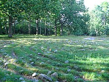
Greby burial ground

The greby with about 200 barrows and stone circles located north of Grebbestad in the municipality of Tanum in Västra Götaland County . It is one of the largest burial grounds on the Swedish west coast.
description
The burial ground covers an area of about 300 × 210 meters, on which there are 68 round burial mounds , 54 long mounds, 47 round stone settings , 12 oval stone settings and 38 building stones . 28 building stones stand on burial mounds or in stone settings. The burial mounds and stone settings vary greatly in their dimensions. Several burial mounds are sunk in the middle, and a boulder lies in one of the pits. The building blocks are between 1.4 and 2.9 meters high and between 0.5 and 1.5 meters wide. Several stones fell over, two were raised again in 1977. In the northern part of the field, four large stone slabs stand side by side, one of which is decorated with a wheel cross and a segment of a circle.
The archaeologist Oscar Montelius (1843–1921) found burial urns with burial objects such as fragments of bone combs, pearls and hand spindles while examining eleven graves in 1873 ; there was a window urn in a grave . The graves consisted of a layer of field stones, which was covered with earth and sand; At the bottom of the graves there was a layer of ash which, according to Montelius, came from the cremation of the corpses . Montelius dated the burial ground to the 4th and 5th centuries AD.
In the surrounding area, the stone circles of Sövall and are Trojaburg of Ulmekärr from the Bronze Age .
interpretation
According to local tradition, Scottish warriors who had come to fish on the Swedish west coast to fish and fell in a battle against the Teutons living there were buried on the grave field . This orally transmitted explanation is not supported by the finds.
According to archaeologists Lasse and Kristina Bengtsson, the burial ground belonged to a trading post that was probably abandoned in the 6th century AD. This is supported not only by the ceramics, which are unusual for Sweden, but also by other finds in the area, as well as some place names that indicate a seaport near Grebbestad that was usable in the 5th century.
literature
- Wolfram zu Mondfeld: Viking trip . Koehler, Herford 1985, ISBN 3-7822-0360-7 , pp. 102 .
- Mikael Jägerbrand: Greby gravfold. Guidebok om Sveriges vackraste gravfalt. Virvelvind, Lysekil 2010, ISBN 978-91-975331-5-7 .
Web links
- Grave field of Greby - entry in the database "Fornsök" des Riksantikvarieämbetet (Swedish)
Individual evidence
- ↑ Greby cemetery - entry in the database "Fornsök" des Riksantikvarieämbetet (Swedish)
- ↑ a b Kristina Svensson: Fornminnet Greby gravfalt , in: Popular Historia , 8/2008, ISSN 1102-0822 ( online )
- ^ Henry Carlsson et al .: Kulturminnesvårdsprogram för Tanums kommun , Tanum 1984, p. 124 f. ( online )
Coordinates: 58 ° 42 ′ 2.8 ″ N , 11 ° 15 ′ 40 ″ E

