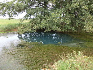
Gründleinsloch (Castell)
| Gründleinsloch | |||
|---|---|---|---|
 Gründleinsloch |
|||
| location | |||
| Country or region | District of Kitzingen , Lower Franconia ( Bavaria ) | ||
| Coordinates | 49 ° 44 ′ 58 " N , 10 ° 21 ′ 8" E | ||
|
|||
| geology | |||
| Mountains | Steigerwald | ||
| Source type | Gypsum karst spring | ||
| Exit type | Source pot | ||
| rock | limestone | ||
| Hydrology | |||
| River system | Rhine | ||
| Receiving waters | Gründleinsbach → Castellbach → Schwarzach → Main → Rhine → North Sea | ||
Coordinates: 49 ° 44 ′ 58 ″ N , 10 ° 21 ′ 8 ″ E
The Gründleinsloch is a gypsum karst spring near Castell on the edge of the Steigerwald in the Kitzingen district in Lower Franconia .
description
The source is on a plain between Castell and Greuth , in a wooded area near the KT 11 district road . The source pot is the origin of the 9 km long Gründleinsbach , which flows over the Castellbach into the Schwarzach . The source rises from the gypsum rock below the Hahnhart (319 m). The crystal clear spring water comes out from a great depth and shimmers slightly bluish at the exit point. Divers found a several meters large cavity washed from the limestone under the exit point.
Popular beliefs and legends
In the past you saw something threatening in the Gründleinsloch. The origin of the blue shimmering water from the uncanny depths could not explain the people. Since no one could see the bottom of the source, it was believed that it was a bottomless hole; hence the name Gründleinsloch.
According to a legend, there is an underground passage between the fountain at the ruins of the Castellschen ancestral castle on the nearby Schlossberg and the Gründleinsloch. The legend says that if you throw a duck into the fountain on Schlossberg, it will come out again at Gründleinsloch.

