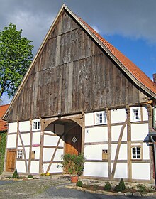
Grevinghof
The Grevinghof is a historic farm in Westerbönen in North Rhine-Westphalia . It was a fiefdom of the Brandenburg region , mentioned in 1392/93 in the earliest loan book of the Counts of the Mark and at that time lent to Wennemar von Bögge .
history
In the commentary on the loan book, the history of ownership of the farm from the 15th century is given, as well as a brief description: "Grevinghof zu Westerbönen, formerly fortified with a moat, taxed the highest amount of 6 guilders in 1486 (Treasury book p. 36), only had it in 1683 a desolate house, no more buildings in 1713, inhabited again at the end of the 18th century. " The fact that the house was in a desolate location in 1683 is probably correct, since armed conflicts between the Great Elector Friedrich Wilhelm of Brandenburg and the French King Louis XIV took place in this area during this period. The troops of the Prince-Bishop of Munster, who was allied with the Sun King, set fire to the ground here. The Grevinghof may also have been devastated. However, the statement does not apply that the Grevinghof was only built at the end of the 18th century. was inhabited again. Because in the cadastre of the Prussian government from 1705 the tax burdens for the Grevinghof are listed. According to the inscription on the Wulf beam, the main house, which still stands today, was built in 1742 by Othmer Johan Grevinghof and his wife Clara Anna, née. Pile, erected.
etymology
The name Grevinghof is derived from " Greve " (head of a rural district with judicial functions) and "inge" (descendants). The "Grevinge" therefore owned this farm as their headquarters. The office of Greven was probably connected to the court for several generations, otherwise the name Greve would not have been transferred to the estate.
location
According to the original map from 1828, the Grevinghof presents itself as a moat system partially traversed by a stream, in which an island was also surrounded by its own moat . On this island stood a timbered keep built in the 15th century. The course of the graves can still be traced in the area today. The entire courtyard is protected as a ground monument, as a largely unbuilt fiefdom from the late Middle Ages has survived here.
Duration
The core of the courtyard is the Low German Hall House , which was built in 1742 as a residential and farm building in four-column construction, locked three times, secured with struts and also provided with a forecourt. At the end of the 19th century, the economic part was no longer sufficient, so that stables, partly in brick, partly in half-timbered, were added to the east and west aisles. To the east of the living area there is a half-timbered warehouse from the beginning of the 19th century, which was formerly used as a bakery . Around 1914 a spacious barn was built to replace an older one. The extensions are arranged in such a way that an impressive U-shaped complex has been created. As a witness of the agricultural change from the pre-industrial to the industrial era, it is protected as a monument .
Individual evidence
- ^ Margret Westerburg-Frisch, The oldest loan books of the Counts von der Mark (1392 and 1393), Münster 1967, p. 8 and 117.
- ↑ ibid., P. 80.
- ^ Willy Timm, cadastre of contributory goods in the county of Mark 1705, Münster 1980. No. 541.
- ↑ cf. Paul Grävinghoff, The meaning of the family name Grävinghoff, in: Journal of the genealogical-heraldic society Roland zu Dortmund eV, Volume 16 (1982), Vol. 5, Issue 9.
- ↑ Loan letter from 15.17.1434 in: Document records from the Wilbring archive / digital Westphalian document database (DWUD), finding aid A 472
Coordinates: 51 ° 36 '24 .4 " N , 7 ° 46" 39.4 " E

