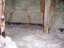
Grimes Graves
Grimes Graves (also Grime's Graves) is a Neolithic flint mine in the Breckland of Norfolk in eastern England . It is seven miles northwest of Thetford on the A134 (OS Map 144; ref TL 818898).
Dating
The mine dates back to the Grooved Ware era . The shaft entrances and the accompanying overburden are exceptionally well preserved, presumably because of the location on the border between two parishes. Compared to the Silex mines of the Sussex Downs , such as Cissbury , Church Hill, Blackpatch , Harrow Hill and Martin's Clump and of Wessex (Durrington, Easton Down), the mining here starts surprisingly late.
Raw material
The mines were dug with deer antlers. The raw material obtained here ( Brandon Flint ) is very fine-grained and homogeneous, with a characteristically black color. Only the so-called " floorstone " was used, which provides particularly large and homogeneous raw material lumps , while those of the deposits above ( topstone , wallstone ) are often small and very eccentric in shape.
| Flint layer | depth |
|---|---|
| Topstone | 5.9 m |
| Wallstone | 8.2 m |
| Floorstone | 12 m |
433 shafts are visible above ground as hollows on an area of 7.6 hectares. In the nearby Brandon , flint for rifles was extracted and processed from this material until the early 20th century.
Excavations
William Camden described the site as a fortification in 1695, while F. Blomefield thought it was a fortified Danes' camp in 1805 . The first excavations took place in 1852. From 1868–1870 the priest and antiquarian William Greenwell dug the first shaft down to the ground and explored the side corridors (Greenwell pit). The Prehistoric Society of East Anglia excavated two more shafts in 1914, investigations by A. Armstrong followed between 1923 and 1939. The finds were given to the British Museum. The excavations by Roger Mercer 1971–72 were followed by research at the British Museum from 1972–1976 under the direction of Ian Longworth and Gale Sieveking . The excavations themselves were carried out by a Dutch team who had already examined the Rijckholt mine in Limburg .
Finds
The pottery found in the shafts belongs to the Durrington Walls style of Grooved Ware . Both heavy pottery and decorated bowls were found. A 11.5 cm high anthropomorphic limestone figure and a limestone phallus were found in the shaft . The authenticity of the statue has been questioned. Numerous animal bones also come from the filling of the shafts. Whether it is municipal waste or deliberate landfilling ( structured deposition ) is controversial.
literature
- Martyn Barber: The place of flint mines within the Neolithic of Southern England. In: Gabriele Körlin, Gerd Weisgerber (Hrsg.): Stone Age - Mining Age (= The cut. Supplement 19 = publications from the German Mining Museum Bochum. 148). German Mining Museum, Bochum 2006, ISBN 3-937203-27-3 , pp. 55–60.
- William Greenwell: On the opening of Grime's Graves in Norfolk. In: Journal of the Ethnographical Society of London. Neue Serie, Volume 2, 1870, pp. 419-439, doi : 10.2307 / 3014374 .
- Jacek Lech, Ian Longworth: The Grimes Graves site in the light of two late Neolithic workshop assemblages. In: Gabriele Körlin, Gerd Weisgerber (Hrsg.): Stone Age - Mining Age (= The cut. Supplement 19 = publications from the German Mining Museum Bochum. 148). German Mining Museum, Bochum 2006, ISBN 3-937203-27-3 , pp. 413-422.
- Roger J. Mercer: Grimes Graves, Norfolk. Excavations 1971-72 (= Archaeological Reports. Volume 11). 2 volumes. Her Majesty's Stationery Office, London 1981, ISBN 0-116-71055-1 (digital copies : Volume 1 , Volume 2 ).
- Peter Topping, Mark Lynott (Ed.): The cultural landscapes of prehistoric mines. Oxbow, Oxford 2005, ISBN 1-84217-147-X .
Individual evidence
- ↑ Anthony J. Legge: Animals, environment and the Bronze Age economy (= Excavations at Grimes Graves, Norfolk, 1972-1976. Fasc. 4). London, Published for the trustees of the British Museum by the British Museum Press, London 1992, ISBN 0-7141-1399-9 .
Web links
- http://www.bbc.co.uk/norfolk/funstuff/360/grimes_graves.shtml (panorama picture) (last accessed on December 10, 2012)
- http://www.archaeologyuk.org/ba/ba72/feat2.shtml (last accessed December 10, 2012)
- (The Goddess; last accessed February 26, 2013)
Coordinates: 52 ° 28 ′ 33 ″ N , 0 ° 40 ′ 31 ″ E

