Högakustenbron
Coordinates: 62 ° 47 ′ 52 ″ N , 17 ° 56 ′ 19 ″ E
| Högakustenbron | ||
|---|---|---|
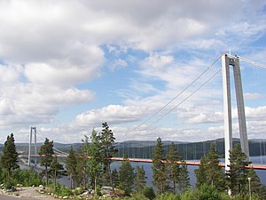
| Högakustenbron, view from the east | ||
| Official name | Högakustenbron | |
| use | Road bridge | |
| Convicted | Europastraße 4 | |
| Crossing of | Ångermanälven | |
| place | Kramfors | |
| construction | Suspension bridge | |
| overall length | 1867 m | |
| width | 17.8 m | |
| Longest span | 1210 m | |
| height | 186 m | |
| Clear height | 40 m | |
| opening | December 1, 1997 | |
| location | ||
|
|
||
| South driveway | ||
Högakustenbron ( German Hochküstenbrücke ) is a suspension bridge over the Ångermanälven river in the Swedish municipality of Kramfors . The bridge, opened in 1997, is a road bridge for the European route E4 and the second tallest structure in Sweden: The maximum span of the bridge is 1,210 m and is therefore almost as long as that of the Golden Gate Bridge (1,280 m). Its clear height is 40 m, the total height is 186 m with a total length of 1,867 m. The bridge is 17.8 m wide.
Panoramic view of the bridge
Web links
Commons : Högakustenbron - album with pictures, videos and audio files
- www.hogakustenbron.nu - website for the Högaksuten Bridge of the municipality of Kramfors and the Swedish road construction authority Vägverket


