Hammerfest Harbor
| Hammerfest Harbor | |||
|---|---|---|---|
| Data | |||
| UN / LOCODE | NOHFT | ||
| owner | Hammerfest Havnevesen | ||
| Port type | Sea port , ice-free all year round | ||
| Throughput | no information available as of 2012 |
||
| website | www.hammerfesthavn.no | ||
| Geographic information | |||
| place | Hammerfest | ||
| kingdom | Norway | ||
| Country | Norway | ||
| Part of Hammerfest Harbor 2005 | |||
| Coordinates | 70 ° 39 '49 " N , 23 ° 41' 13" E | ||
|
|||
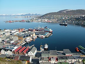
The port of Hammerfest is one of the northernmost seaports in Europe and is ice-free all year round. It is located on the European Arctic Ocean and in the city of the same name in northern Norway and the municipality of Hammerfest .
The main port in the west of Finnmark , Troms og Finnmark Province , was recognized by the EU in 1996. Today there is a Veterinary Port Control Authority. Much of the handling is now done by the local fishing industry. In addition, ships dock on the Hurtigruten in Hammerfest. The local ferry and bus company FFR serves the settlements on the surrounding islands with the catamaran high-speed boats .
The three tugs Boris , Barents and Banak from Buksér og Berging AS in Hammerfest are available for safe navigation into the port .


